Saturday, June 8, 2013

Sunday Night – Tuesday Morning Rain Totals Forecast


          Here is the new rainfall forecast for Sunday Night through Tuesday Morning. As you can see more rain is expected to fall, and just add the the rainfall we have already had. After this system passes, many more rainstorms are expected from the active pattern this month. Get ready for one of the wettest June's in several years! Keep it here at Northeast Weather Action for the latest updated forecasts on this storm as well as many other rainy encounters we will have in the next few weeks! Here is the new 12z Euro model showing the rainfall that could be produced by this storm system.


Is Even More Rain Coming? Find Out!

          Tropical Storm Andrea impacted the northeast with heavy rain in  with rainfall amounts in excess of six inches in some locations. So this might have you thinking we are going to have lots of sun now, well that is not correct really at all. A strong low pressure system in the central and high plains will dump heavy rain there, which is good for them because of the upcoming fire season. But where exactly will all of this rain go, well read on to find out! Well the low will glide east into the Midwest and them through the Ohio Valley, eventually into our region, by Monday. The low will then cut through western Pennsylvania and central New York, and into west-central New England, through Maine.

          The rainfall totals should be a widespread 1 to as many as 3 inches. The most rain will fall in an area that was hammered by lots of rain yesterday, New England. Here is the HPC's rain forecast for the next 1 - 3 days, but this is not the only storm that is coming to our area, so be sure to read on after the forecast graphic.


          Yet another rainstorm is coming for the middle of next week, but the track of it will be slightly more south then this storm coming on Monday. This storm will ride though central and northern Ohio, into extreme southwestern New york and western PA. From this point the storm will, likely go into south central Pennsylvania, into northern West Virginia, and Maryland and New Jersey. Rainfall from that will be from about 1 to as much as 2 inches. Keep stay tuned to Northeast Weather Action for the latest rainfall forecasts on these storms as well as forecasts and outlooks on all northeast weather action!

Be Sure To Stay Connected With Northeast Weather Action!

NEWXAction


Wednesday, June 5, 2013

1st Update On T.S. Andrea And It's Affects On The Northeast


Total Precipitation Forecast From Both Lows


BREAKING NEWS : TROPICAL STORM ANDREA HAS FORMED AND WILL GET ADVISORIES WITHIN THE NEXT HOUR

Click to unzoom Return to Atlantic Graphical TWO
1. AN AIR FORCE RECONNAISSANCE AIRCRAFT WAS ABLE TO IDENTIFY A
WELL-DEFINED CIRCULATION IN THE LOW PRESSURE AREA OVER THE EAST-
CENTRAL GULF OF MEXICO LATE THIS AFTERNOON. BASED ON THIS
FINDING...THE NATIONAL HURRICANE CENTER WILL INITIATE ADVISORIES ON
TROPICAL STORM ANDREA WITHIN THE NEXT HOUR OR SO. THIS SYSTEM HAS A
HIGH CHANCE...NEAR 100 PERCENT...OF BECOMING A TROPICAL CYCLONE
DURING THE NEXT 48 HOURS.

New Weekly Weather Videos To Begin

          I have been thinking what to do to really make Northeast Weather Action the most up-to-date weather blog out today, and I thing I came up with a good idea. From now on, every week, I will have a weekly weather video. This video will express the coming week of weather to keep you alert for northeast weather action. The videos will start tomorrow, the video should be out by 3 PM EST. I hope you enjoy them and I will still do regular posting, now even more often. I will post a link for the video when it is out, that goes along with whenever I make a video. Thanks for your time and keep tuned in!

New NHC Update As Of 5:00 PM EST On Invest 91L


Click to unzoom 
1. A BROAD AND ELONGATED AREA OF LOW PRESSURE OVER THE CENTRAL GULF OF
MEXICO CONTINUES TO PRODUCE A LARGE AREA OF THUNDERSTORMS AND WINDS
TO NEAR GALE FORCE OVER THE SOUTHEASTERN GULF OF MEXICO.  SATELLITE
AND SURFACE DATA SUGGEST THAT THE CIRCULATION REMAINS POORLY
DEFINED...HOWEVER AN AIR FORCE RESERVE RECONNAISSANCE AIRCRAFT IS
SCHEDULED TO INVESTIGATE THE DISTURBANCE THIS AFTERNOON.  ALTHOUGH
ENVIRONMENTAL CONDITIONS ARE NOT CONDUCIVE FOR SIGNIFICANT
DEVELOPMENT...THERE IS POTENTIAL FOR THIS SYSTEM TO BECOME A
TROPICAL DEPRESSION OR STORM BEFORE IT MOVES ACROSS NORTHERN
FLORIDA LATE THURSDAY OR THURSDAY NIGHT.  THIS SYSTEM HAS A HIGH
CHANCE...60 PERCENT...OF BECOMING A TROPICAL CYCLONE DURING THE
NEXT 48 HOURS.  


THIS SYSTEM HAS ALREADY PRODUCED TORRENTIAL RAINS AND FLOODING 
OVER THE EASTERN YUCATAN PENINSULA AND WESTERN CUBA.  REGARDLESS 
OF DEVELOPMENT...ADDITIONAL HEAVY RAINS AND GUSTY WINDS ARE 
EXPECTED OVER THE FLORIDA KEYS AND THE FLORIDA PENINSULA DURING
THE COUPLE OF DAYS.  ISOLATED TORNADOES ARE ALSO POSSIBLE OVER 
THE FLORIDA PENINSULA LATE TONIGHT THROUGH THURSDAY.  ADDITIONAL
INFORMATION ON THIS SYSTEM AND ITS EFFECTS CAN BE FOUND IN HIGH
SEAS FORECASTS ISSUED BY THE NATIONAL WEATHER SERVICE...AND IN
PRODUCTS ISSUED BY YOUR LOCAL NATIONAL WEATHER SERVICE OFFICE OR
NATIONAL METEOROLOGICAL SERVICE. 

Tuesday, June 4, 2013

New Update From NHC On Invest 91L

Click to unzoom

1. DISORGANIZED SHOWERS AND THUNDERSTORMS ASSOCIATED WITH A BROAD AREA
OF LOW PRESSURE OVER THE CENTRAL GULF OF MEXICO ARE LOCATED WELL
EAST AND SOUTHEAST OF THE CENTER. ENVIRONMENTAL CONDITIONS COULD
BECOME A LITTLE MORE CONDUCIVE FOR DEVELOPMENT DURING THE NEXT DAY
OR TWO BEFORE THE LOW INTERACTS WITH AN UPPER-LEVEL TROUGH. THIS
SYSTEM HAS A MEDIUM CHANCE...40 PERCENT...OF BECOMING A SUBTROPICAL
OR TROPICAL CYCLONE DURING THE NEXT 48 HOURS AS IT MOVES SLOWLY
NORTHWARD TONIGHT AND WEDNESDAY AND BEGINS TO MOVE MORE QUICKLY
NORTHEASTWARD ON THURSDAY. REGARDLESS OF DEVELOPMENT...LOCALLY
HEAVY RAINS ARE LIKELY TO CONTINUE OVER THE NORTHEASTERN YUCATAN
PENINSULA...CENTRAL AND WESTERN CUBA...AS WELL AS THE FLORIDA KEYS
AND THE FLORIDA PENINSULA DURING THE NEXT FEW DAYS. ADDITIONAL
INFORMATION ON THIS SYSTEM CAN BE FOUND IN HIGH SEAS FORECASTS
ISSUED BY THE NATIONAL WEATHER SERVICE...AND IN PRODUCTS ISSUED BY
YOUR LOCAL NATIONAL WEATHER SERVICE OFFICE OR NATIONAL
METEOROLOGICAL SERVICE. 

June 4th Tropical Update : A Storm Could Be Brewing

          As we move into the beginning of hurricane season, we possibly already have something to watch. A tropical wave in the Caribbean that is now Invest 91L, is slowly drifting north-northeast. The probability of development is about 40% at this time, but could increase later today or tomorrow. The area this system is trying to form in is the most normal and favorable region in the Atlantic for this time of year. Despite the unfavorable upper-level conditions, this low still has a chance of forming into a tropical depression or weak tropical storm. We do not expect this low to strengthen much past the weak to possible moderate tropical storm level. This area of low pressure is moving towards the Florida Peninsula.

          Regardless whether or not this storm strengthens into a tropical entity, it will still produce heavy rainfall especially in Florida, but possibly up the east coast. The models as this morning were generally taking the system off the coast in the Carolina's, but some of the more recent models are beginning to shift it closer to the coast. Rainfall amounts in Florida will likely be very substantial and impactful. Another factor going into the rainfall totals here in the northeast is there will be another system, not tropical related at all gliding into western and central PA, as well as western and central New York. But this is likely to occur at the same time as the tropical lows effects on the northeast, and this makes for some possible significant rainfall.

          Like I said, the models are beginning to take this system up the coast and really starting to impact coastal areas with lots of precipitation. But also in addition, western and centrals areas of New York and Pennsylvania will get more rain from another low. It is still possible the tropical system could go off the coast, but the path of that is still to be determined. Now I am going to show you a model that I think is great for showing the amount of precipitation that will fall throughout this system. Here is the newest 12z euro showing precipitation amounts from these two systems combined.


          As you can see, the highest rainfall amounts are in northeast New Jersey, into southeast New York, and into southern New England. After that you notice the area of enhanced precipitation in the eastern Ohio Valley and central New York, which is produced by the second system non-tropical. Overall the timing for this storm will be on Friday afternoon, the tropical low will likely be somewhere in northeast Northeast Carolina or on the southeast Virginia Cape. The system will then glide northeast, and be just west of New York City during early Saturday morning, so the low will be faster moving then normal. The storm will likely be off down east Maine by Saturday afternoon. This system is nothing to really get ready for, but will be noticeably impactful here in the northeast, I will leave you with the overall setup of these two lows and where the heaviest rain could fall.


Monday, June 3, 2013

Get Ready, A Much Needed Cool Down Is On It's Way!

          After near record high temperatures with the extreme heat that we encountered with from the middle part of last week, up until yesterday, a relief is on the way. A front passed through the region yesterday night, causing thunderstorms to flare, but behind that front is much needed late spring-like temperatures. Now don't be fooled, it will not be cold, but more of a slightly below normal to just a below normal pattern will set up. The highs and lows will likely be moderating throughout this period. Highs will be very different, depending on where you are in the northeast. It looks like from New England, through northern Ohio will be the coldest. This cool down will last from today - about two weeks or more from now, so it will be sticking around.

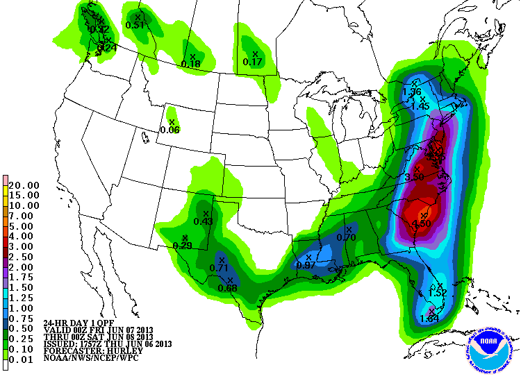
          You keep on reading how this is going to be a cool down, well it won't be too big, but just enough to maybe keep you out of the pool in some spots. Temperatures will drop 3 to as much as 10 degrees below normal. The most noticeable time frame in the cool down will be from June 6th - 8th. This is when highs could only be in the 60's from Syracuse to Hartford, with highs in the low to mid 70's from Philly to D.C.. This is during the 6th - 9th, but after that, it appears as though widespread low 70's - low 80's will cover the area. Here is the most recent euro model that shows the highs on June 8th, followed by the 6 - 10 Day Temperature Outlook from the Storm Prediction Center.


          As you can see, highs will be not summer like at all, but more spring like. After that, according to the Climate Prediction Center, the coldest temperatures will be in northwestern Ohio, and the below normal temperatures in the next 6 - 10 days will mainly be confined to as far east as central PA and central New York. But like I said, this will be the coldest period of the cool conditions, as things could start to warm up around June 10th. Next, you can see some above normal temperatures that are in the west, and possibly moving our way in about two weeks from now. Here is a model showing the forecast highs for June 10th, being followed by the 8 - 14 Day Temperature Outlook from the CPC.


          As you can see, some warmer conditions are being indicated to be in our region by June 10th. But as you also see, the outlook forecasts below normal temperatures in our area in the next 8 - 14 days, meaning about 2 - 5 degrees below normal from your average high. So really, there is still some disagreement, but summer is not even here yet, so don't be worried. But what I really wanted to say is, this cool air will not be very significant! Thanks for reading and keep tuned into Northeast Weather Action for the latest updates on this forecast and many other weather events!


Potential Severe Thunderstorm Watch To Be Issued


          The Storm Prediction Center is currently monitoring this area and questioning whether or not to issue a Severe Thunderstorm Watch. Storms are currently firing up in this region and could turn severe. Although a Severe Thunderstorm Watch will most likely not be issued, keep a look out for potential severe and strong storms around this region.

Sunday, June 2, 2013

New England Thunderstorms

Vermont Watches and Warnings Map
Severe Weather Key
Warnings Issued By The National Weather Service / Storm Prediction Center

June 2nd Tropical Update

          As most of us know, yesterday was the official start of the 2013 Hurricane Season. Well can you guess what we have, possible tropical development! Former Tropical Storm Babara moved through central Mexico and into the southeast Gulf of Mexico. It could possibly into a tropical storm sometime late this week. The models show this storm organizing into a system that could be tropical, which makes possible landfall just north of Tampa, FL. Significant rains are likely to fall no matter what with this system makes landfall but believe it or not, this storm could have an impact on our region.
       
          It is possible that this storm could ride up the east coast and impact coastal areas with heavy rain here in the northeast. The National Hurricane Center gives this system a 10% chance of developing into a organized tropical depression or storm in the next two days, but like I said this system will not likely develop in the next 48 hours. Now here is the track that this storm could take before running off the Mid-Atlantic coastline and the estimated precipitation amounts with this system.


SPC Could Issue Severe Thunderstorm Watch

Mesoscale Discussion 937
< Previous MD
MD 937 graphic
   MESOSCALE DISCUSSION 0937
   NWS STORM PREDICTION CENTER NORMAN OK
   0218 PM CDT SUN JUN 02 2013

   AREAS AFFECTED...PARTS OF THE MID-ATLANTIC

   CONCERNING...SEVERE POTENTIAL...WATCH POSSIBLE 

   VALID 021918Z - 022145Z

   PROBABILITY OF WATCH ISSUANCE...40 PERCENT

   SUMMARY...ISOLATED/MARGINALLY SEVERE TSTMS IN THE LEE OF THE CNTRL
   APPALACHIANS MAY DEVELOP EWD TOWARDS THE I-95 CORRIDOR THIS EVENING.

   DISCUSSION...A FEW TSTMS HAVE DEVELOPED ACROSS FAR NRN VA/ERN WV
   PANHANDLE...WITH ADDITIONAL AGITATED CU NOTED ON VISIBLE SATELLITE
   IMAGERY NEWD INTO ERN PA. WITH THE SHORTWAVE TROUGH AXIS EVIDENT IN
   WATER VAPOR IMAGERY RUNNING FROM THE LEE OF LK ONTARIO INTO NERN
   PA...THERE IS SOME UNCERTAINTY AS TO THE DEGREE OF TSTM COVERAGE IN
   THE NEXT FEW HOURS GIVEN THE DAMPENING/NEWD MOVEMENT OF THE TROUGH
   AWAY FROM THE REGION. STILL...A MODESTLY UNSTABLE AIR MASS WITH
   MLCAPE NEAR 1000 J/KG AMIDST PREVALENT MIDDLE 80S SURFACE
   TEMPERATURES COULD FOSTER FURTHER DEVELOPMENT. WITH THE REGION LYING
   ON THE PERIPHERY OF THE STRONGER MID-LEVEL SWLYS...A FEW MARGINALLY
   ORGANIZED TSTMS SHOULD POSE A RISK OF ISOLATED SEVERE HAIL AND
   DAMAGING WINDS.

   ..GRAMS/WEISS.. 06/02/2013


   ATTN...WFO...OKX...PHI...BGM...AKQ...CTP...LWX...

   LAT...LON   41387505 41067436 40627442 39257542 38187672 38107744
               38357840 38757855 39447782 40777644 41287583 41387505 

Possible Severe Thunderstorm Watch To Be Issued


Possible Severe Thunderstorm Watch Area - Not Issued Yet


Severe Thunderstorm Watch Issued For Eastern New York and New England


WW0271 Overview WOU Image
   WOUS64 KWNS 021530
   WOU1

   BULLETIN - IMMEDIATE BROADCAST REQUESTED
   SEVERE THUNDERSTORM WATCH OUTLINE UPDATE FOR WS 271
   NWS STORM PREDICTION CENTER NORMAN OK
   1135 AM EDT SUN JUN 2 2013

   SEVERE THUNDERSTORM WATCH 271 IS IN EFFECT UNTIL 800 PM EDT
   FOR THE FOLLOWING LOCATIONS

   CTC003-005-030000-
   /O.NEW.KWNS.SV.A.0271.130602T1535Z-130603T0000Z/

   CT 
   .    CONNECTICUT COUNTIES INCLUDED ARE

   HARTFORD             LITCHFIELD          


   MAC003-011-013-015-017-027-030000-
   /O.NEW.KWNS.SV.A.0271.130602T1535Z-130603T0000Z/

   MA 
   .    MASSACHUSETTS COUNTIES INCLUDED ARE

   BERKSHIRE            FRANKLIN            HAMPDEN             
   HAMPSHIRE            MIDDLESEX           WORCESTER           


   MEC001-003-005-007-011-017-019-021-025-031-030000-
   /O.NEW.KWNS.SV.A.0271.130602T1535Z-130603T0000Z/

   ME 
   .    MAINE COUNTIES INCLUDED ARE

   ANDROSCOGGIN         AROOSTOOK           CUMBERLAND          
   FRANKLIN             KENNEBEC            OXFORD              
   PENOBSCOT            PISCATAQUIS         SOMERSET            
   YORK                 


   NHC001-003-005-007-009-011-013-015-017-019-030000-
   /O.NEW.KWNS.SV.A.0271.130602T1535Z-130603T0000Z/

   NH 
   .    NEW HAMPSHIRE COUNTIES INCLUDED ARE

   BELKNAP              CARROLL             CHESHIRE            
   COOS                 GRAFTON             HILLSBOROUGH        
   MERRIMACK            ROCKINGHAM          STRAFFORD           
   SULLIVAN             


   NYC001-019-021-027-031-035-039-057-083-091-093-095-111-113-115-
   030000-
   /O.NEW.KWNS.SV.A.0271.130602T1535Z-130603T0000Z/

   NY 
   .    NEW YORK COUNTIES INCLUDED ARE

   ALBANY               CLINTON             COLUMBIA            
   DUTCHESS             ESSEX               FULTON              
   GREENE               MONTGOMERY          RENSSELAER          
   SARATOGA             SCHENECTADY         SCHOHARIE           
   ULSTER               WARREN              WASHINGTON          


   VTC001-003-005-007-009-011-013-015-017-019-021-023-025-027-
   030000-
   /O.NEW.KWNS.SV.A.0271.130602T1535Z-130603T0000Z/

   VT 
   .    VERMONT COUNTIES INCLUDED ARE

   ADDISON              BENNINGTON          CALEDONIA           
   CHITTENDEN           ESSEX               FRANKLIN            
   GRAND ISLE           LAMOILLE            ORANGE              
   ORLEANS              RUTLAND             WASHINGTON          
   WINDHAM              WINDSOR             


   ATTN...WFO...BOX...BTV...ALY...GYX...CAR...


Aviation Watch (SAW) for WW271
WW0271 Overview Image
Note: The Aviation Watch (SAW) product is an approximation to the watch area. The actual watch is depicted by the shaded areas.
   SAW1 
   WW 271 SEVERE TSTM CT MA ME NH NY VT 021535Z - 030000Z
   AXIS..80 STATUTE MILES EAST AND WEST OF LINE..
   65NW HUL/HOULTON ME/ - 40SSW PSF/PITTSFIELD MA/
   ..AVIATION COORDS.. 70NM E/W /28W PQI - 41W BDL/
   HAIL SURFACE AND ALOFT..1.5 INCHES. WIND GUSTS..60 KNOTS.
   MAX TOPS TO 500. MEAN STORM MOTION VECTOR 24035.

   LAT...LON 46776708 41887204 41887515 46777045

   THIS IS AN APPROXIMATION TO THE WATCH AREA.  FOR A
   COMPLETE DEPICTION OF THE WATCH SEE WOUS64 KWNS
   FOR WOU1.

Storm Prediction Center's Forecasts

Tornado Probabilities


Wind Probabilities


Hail Probabilities


Our YouTube Videos