

Showing posts with label NOAA Weather. Show all posts
Showing posts with label NOAA Weather. Show all posts
Friday, June 28, 2013
Will There Be Severe T-Storms Tomorrow? Find Out!
The past several days have been filled with threats for strong to severe thunderstorms. So will tomorrow be the same kind of thing? Well it really depends on where you exactly live. If you are in Ohio or New York, you don't need to be concerned, but if you are located in Eastern PA, most of New Jersey and on the central and western part of the Del-Mar-Va, you run into some small problems. This area is where some storms could turn on the strong side, so just keep an eye on the radar tomorrow! Also keep in mind of the flash flood threat because we have has lots of rain and a little to much in some places. Here is tomorrows severe thunderstorm forecast. Be sure to stay tuned in to Northeast Weather Action for the latest weather forecasts and updates, have a great Friday night!


Updated 7 Day Rain Forecast - Keep The Umbrella Out
Today and tomorrow will feature showers around the area with some heavier rain perhaps hanging around in New England. From Sunday into the majority of next week, several low pressure systems will produce significant amounts of rain throughout the region. So keep the umbrella out because you will need it again. With everything said, here is the precipitation forecast for the next 7 days. More rain is coming so as always stay right here at Northeast Weather Action for the latest weather forecast and updates! Have a great weekend!

Today's Severe Thunderstorms Threats - Nothing Like Yesterday
Today there will be some isolated strong thunderstorms, but mainly more shower activity and a few embedded storms. Yesterday we had many flash flood warnings and several severe thunderstorm warnings, as well as even a few tornadoes in Pennsylvania. But that was yesterday, today is not expected to be anything close to that magnitude.
Overall there is a low threat of strong to severe storms across the region with a moderate threat which is still not noticeable, in New Jersey and on the Del-Mar-Va. This is the area where some wind damage in storms are possible. So you don't have much to worry about when going to outdoor activities. Here is today's severe thunderstorm threats forecast, have a great day and stay tuned to Northeast Weather Action for the latest forecasts and updates on all northeast weather action!

Overall there is a low threat of strong to severe storms across the region with a moderate threat which is still not noticeable, in New Jersey and on the Del-Mar-Va. This is the area where some wind damage in storms are possible. So you don't have much to worry about when going to outdoor activities. Here is today's severe thunderstorm threats forecast, have a great day and stay tuned to Northeast Weather Action for the latest forecasts and updates on all northeast weather action!

Thursday, June 27, 2013
Full Weekend Weather Forecast
As far as weather conditions go, isolated thunderstorms with some rain showers in Northern Maine. Temperatures should be in the 70's and 80's widespread throughout the region.


Now Through Late Next Week's Rainfall Forecast : To Be Wet
In the past few weeks, we have not had much rain across the region. In the next 7 days, several storms will give every area in the region a high chance of seeing a significant amount of rain. It's looking like the most rain will fall in Eastern Pennsylvania and Eastern New York, where around 4 - 5 total inches of rain is expected to fall in the next 7 days. In the next week, just about every other day an individual storm will arrive in the region just to soak areas that have all ready had a shower. So just how much rain are we in the northeast as a whole expecting, well here is the forecast for the next 7 day's rainfall all in one combined forecast.


Today's New Severe Thunderstorm Threats Forecast
Today will likely be the worst day of the week when it comes in terms of strong to severe thunderstorms. There will likely be widespread thunderstorms especially in New York and Pennsylvania. The storms could pack damaging winds and very heavy downpours. Here is the updated forecast for the t-storm threats index.


Wednesday, June 26, 2013
Wednesday's Updated Severe Thunerstorm Index
The threat today will be the smallest of the week overall. Isolated strong storms could be upon some areas but no real widespread severe t-storm threat is expected. But stay right here to Northeast Weather Action because it is looking like tomorrow and Friday could hold significant threats for severe thunderstorms! Here is today's updated severe thunderstorm index.


Tuesday, June 25, 2013
TWO SEVERE THUNDERSTORM WATCH BOXES ISSUED
| < Previous WW Next WW > |
| ||||||||||||||||||
|

| < Previous WW |
| ||||||||||||||||||
|


Today's Updated Severe Thunerstorm Threats Index
Today is going to have the same general threats as yesterday, but possibly an elevated threat level in some areas. Thunderstorms today are looking to be just as widespread as yesterday packing the threats of damaging winds, small hail, and cloud to ground lightning. The chance of tornadoes today is very low. The rest of the week could hold even higher probabilities for strong to severe thunderstorms so make sure you stay right here at Northeast Weather Action for the latest forecasts and updates, as there will be many. Here is today's updated severe thunderstorms threats index. Stay safe and have a great rest of your Tuesday!


Severe Thunderstorm Watch Could Be Issued
| Mesoscale Discussion 1218 | |
| < Previous MD Next MD > | |
 | |
| |
Saturday, June 22, 2013
All Around Weather Analysis - June 22, 2013
Severe T-Storm Index:
Low Activity
A slight risk for strong to severe thunderstorms runs from Sunday through Wednesday. Minimal activity is expected and chance of impact on your area is low. From Thursday through next weekend, a slight - moderate risk exists for Pennsylvania. New Jersey, New York, as well as all of Southern New England. Isolated activity is possible with risk of impact low to moderate. Main threats: damaging winds in excess of 60 mph and small hail. Probability of a tornado: nearly 0%. Preparation activity needed is nearly nothing, normal thunderstorms could occur in this time period.
Heat Index:
Significant Activity
Slightly above average temperatures are expected throughout the course of the weekend with highs topping out from the 70's to the 80's region wide. A medium duration heat wave is anticipated starting Monday of next weekend, and stretching through midweek, ending Wednesday or Thursday, depending on location. Temperatures will range from 80's in the north to 90's in the south. Thursday - Saturday is expected to have dropping temperatures, about 2 degrees per day. Be sure to drink lots of water and remain hydrated when being exposed to high heat.
Precipitation Index:
Low - Medium Activity
Little to no precipitation is expected from today - Sunday. an increased probability of precipitation will occur Monday and last into the mid to late week as instability is widespread through atmosphere. Maximum chance of precipitation in region: 30%. From Thursday - Saturday, a low pressure system will enter the Ohio, Pennsylvania, and Western New York area. Expected precipitation amounts range from a half an inch in the Northeastern tier on Pennsylvania to near an inch in Northwestern Pennsylvania. Maximum probability of rainfall at current point: 50%.
Drought Index:
Low Activity
An abnormally dry time period with the lack of precipitation could lead to a lack of plant growth. No drought conditions are expected at this time in any part of the region. A relief is likely to come later next week. Area most at risk of below normal precipitation is in the lakes region on Central New York. Any change in forecast has a minimum chance of occurrence.
Tropical Index:
Medium Activity
No tropical activity is expected to to the unfavorable upper and mid level wind conditions at this point, causing increased levels of shear across common tropical development region. Long range index includes an increased possibility for tropical development in the Caribbean. Probability of tropical entity forming in next 10 - 15 days remains around moderate. Keep informed on all development by keeping track of all National Hurricane Center updates and forecasts.
Low Activity
A slight risk for strong to severe thunderstorms runs from Sunday through Wednesday. Minimal activity is expected and chance of impact on your area is low. From Thursday through next weekend, a slight - moderate risk exists for Pennsylvania. New Jersey, New York, as well as all of Southern New England. Isolated activity is possible with risk of impact low to moderate. Main threats: damaging winds in excess of 60 mph and small hail. Probability of a tornado: nearly 0%. Preparation activity needed is nearly nothing, normal thunderstorms could occur in this time period.
Heat Index:
Significant Activity
Slightly above average temperatures are expected throughout the course of the weekend with highs topping out from the 70's to the 80's region wide. A medium duration heat wave is anticipated starting Monday of next weekend, and stretching through midweek, ending Wednesday or Thursday, depending on location. Temperatures will range from 80's in the north to 90's in the south. Thursday - Saturday is expected to have dropping temperatures, about 2 degrees per day. Be sure to drink lots of water and remain hydrated when being exposed to high heat.
Precipitation Index:
Low - Medium Activity
Little to no precipitation is expected from today - Sunday. an increased probability of precipitation will occur Monday and last into the mid to late week as instability is widespread through atmosphere. Maximum chance of precipitation in region: 30%. From Thursday - Saturday, a low pressure system will enter the Ohio, Pennsylvania, and Western New York area. Expected precipitation amounts range from a half an inch in the Northeastern tier on Pennsylvania to near an inch in Northwestern Pennsylvania. Maximum probability of rainfall at current point: 50%.
Drought Index:
Low Activity
An abnormally dry time period with the lack of precipitation could lead to a lack of plant growth. No drought conditions are expected at this time in any part of the region. A relief is likely to come later next week. Area most at risk of below normal precipitation is in the lakes region on Central New York. Any change in forecast has a minimum chance of occurrence.
Tropical Index:
Medium Activity
No tropical activity is expected to to the unfavorable upper and mid level wind conditions at this point, causing increased levels of shear across common tropical development region. Long range index includes an increased possibility for tropical development in the Caribbean. Probability of tropical entity forming in next 10 - 15 days remains around moderate. Keep informed on all development by keeping track of all National Hurricane Center updates and forecasts.
Wednesday, June 19, 2013
A Heat Wave Is On The Way! Find Out When and How Hot!
I take you through the upcoming heat wave approaching the Northeast and Mid-Atlantic and detail when and how hot it will get! Please like Northeast Weather Action on facebook!

Tuesday, June 18, 2013
Preliminary 2013 - 2014 Winter Outlook
I take you in depth on the preliminary winter outlook and go through the factors that have effects on winters. Find Out what you could see for this winter! Please like Northeast Weather Action on facebook! Also visit http://newxaction.blogspot.com/ !
Monday, June 17, 2013
So How Cloudy Is The Northeast Compared To The Rest Of The US? Find Out!
This is a question you may have asked yourself many times when a cloudy and gloomy day is upon you. So here are the real answers to the interesting question. I found this dusty old NOAA chart from almost 20 years ago that likely has then answer. This map was generated by sunshine sensors which are located at almost every observations location. To summarize, it looks like our region here in the northeast is one of the cloudier areas across the country. Where mountain ranges are really determine the amount of sunshine, as you can clearly see for example the Appalachian Mountains in eastern West Virginia. But in the desert southwest, only around 3 out of 10 days have clouds in the sky. But in the Pacific Northwest, 8 out of every 10 days are cloudy. After that, storm tracks have to do somewhat with this forecast, because we see many storms here in the northeast and Great Lakes, more cloudy days are the result.
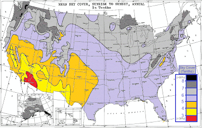


Here is the annual average amounts of precipitation across the lower 48, and as you can see, this map is somewhat coordinated with the map above.

Friday, June 14, 2013
7 - 14 Day Temperatures Forecast
As the first third of June has been average to even slightly below average in terms of temperatures, some summer heat is finally on the way. Only eight days until summer and it will certainly feel like summer from the 22nd through the 29th.


Thursday, June 13, 2013
What Happened To The Severe Weather Today?
As yesterday, the thought was that today we were going to have one of the strongest and most intense severe weather outbreaks of the year. Everyone from the Storm Prediction Center to Northeast Weather Action predicted this. So why didn't we get severe thunderstorms? Well that is a very good question and has a few general answers. I'm sure people from Southern Pennsylvania to Northern Virginia were woken up by a line of severe thunderstorms this morning. Well that line of severe thunderstorms really robbed the atmosphere of all of the instability and shear that was predicted to be present throughout today. After that line of showers and storms passed through the region, we were socked in by clouds which completely ruined the chances of severe thunderstorm formation for today. So in general, the line this morning acted as a shield and protected the area from severe storms.
When you look at the radar, you see intense severe thunderstorms in Virginia or off the coast. Well now you might ask, why do they have severe storms and we have nothing? Very good question once again, but yet again has answers. The reason is because those locations didn't see the squall line in which we did. This in which opened the door for severe weather and didn't close the door on instability, which we here in the Northeast, had the door closed on by. Many people are grateful for this occurrence, but for the storm chasers, no no no, not today! As always be sure to stay tuned to Northeast Weather Action for the latest updates, forecasts, and outlooks on all northeast weather action!
When you look at the radar, you see intense severe thunderstorms in Virginia or off the coast. Well now you might ask, why do they have severe storms and we have nothing? Very good question once again, but yet again has answers. The reason is because those locations didn't see the squall line in which we did. This in which opened the door for severe weather and didn't close the door on instability, which we here in the Northeast, had the door closed on by. Many people are grateful for this occurrence, but for the storm chasers, no no no, not today! As always be sure to stay tuned to Northeast Weather Action for the latest updates, forecasts, and outlooks on all northeast weather action!
Tuesday, June 11, 2013
New Thoughts On Wednesday Night - Friday Morning Rain Event
Yesterday parts of the region received moderate rain all day, like in New England. Meanwhile other sections of the region like Northern Maryland, dealt with tornadoes. Today scattered showers and thunderstorms will be throughout the area. Don't forget about last week's rain from what was Tropical Storm Andrea, or the remnants of it. So with all of this rain, can we possibly expect more. After all, cities like New York City are having one of the top 10 wettest June's of all time, and we are only a third of the way into the month.


This answer to the previous question is yes, do to the active pattern that is constantly tracking storms through the Midwest and Ohio Valley, straight into the Northeast. Now lets get to details on this rainstorm. Showers and thunderstorms Wednesday afternoon across Western PA and New York, as well as Central and Northern Ohio could be severe, with possibly a derecho, which is a long line of severe thunderstorms that cause widespread amounts of damage. This name might seem very familiar to you. It would at around this time last year, two derechos swept through Ohio and from Harrisburg, PA to Richmond, Virginia. These prompted long lasting power outages. Which did not mix the the heat wave we experienced shortly after derechos.
After Wednesday, a low pressure system will approach the region Thursday Morning, shortly after, still likely during Thursday Morning, the storm system will push into Northern Ohio and into Western PA. Heavy is likely to fall, especially on the northern side of the system, which is being indicated on the new models. This. is causing the forecast to change drastically and could still go either way, and could just be a trend that could change. After the rainfall moves into Western PA and Western New York, it will move into Eastern New York as well as Central and Eastern Pennsylvania by around the early afternoon hours on Thursday.
The system is actually looking pretty intense, being forecasted a 997 MB storm in Southeastern PA. When Friday Morning rolls around, the area of low pressure will likely be around Long Island, or just south of it. The rain extent should reach up through Southern New England and into Central New England. Now the southern end of the rain is still more out there, or unknown. On the model I am about to show you, you will see what I am talking about. Here is the new 00z GFS for late Thursday Night, with the low centered in Southeastern PA.

As you can see, it's clear the majority of the rainfall produced by this storm in on the northern side of the system. This is the variable that still has many possibilities but is now becoming more certain. Many models are now showing this solution, so the forecast has changed greatly and looks to be holding throughout the most recent model forecasts. Keep tuned into Northeast Weather Action for the latest rainfall forecasts on this storm. Also stay here because many more storms are coming our way, take my word when I say that. For now I will leave you with the new rainfall forecast for Wednesday Night through Friday at around of just before noon. Thanks for reading!

Monday, June 10, 2013
Today's Updated Severe T-Storm Threats
As severe thunderstorms impacted a portion of the region today, more severe weather is expected to be present tomorrow. The severe storms will mainly be east of the Appalachian, with the risk not as high for some heavy thunderstorms in Ohio. The area with the greatest risk of seeing storms is from in and around Hartford, Connecticut through Eastern Pennsylvania and down into Eastern and Central Virginia. Some storms could contain damaging winds and small hail, as well as heavy downpours. Besides severe weather, some scattered showers, certainly not as widespread as yesterday, will be around. But anyways here is the updated forecast for today's severe thunderstorm threats.


Rain Still To Fall Between This Morning - Tomorrow Night

As heavy rainfall in some spots has already fallen, more rain is expected to fall between now through tomorrow night. Watch out for minor street flooding as well as those streams in your back. After that watch our for some heavy thunderstorms in the afternoon that could be on the severe side as well as just plain downpours. Some of the moisture believe it or not is thanks to tropical moisture, so that is why areas around the coast and just inland could receive the most rainfall. The heaviest rainfall is anticipated to fall between Mt.Pocono, PA, into southeastern New York and over to Springfield, Massachusetts. Watch out for more rain later in the week. Read that forecast to find out where that rain will fall and how much.
Subscribe to:
Posts (Atom)