

Showing posts with label 24 Hour Weather. Show all posts
Showing posts with label 24 Hour Weather. Show all posts
Friday, June 28, 2013
Will There Be Severe T-Storms Tomorrow? Find Out!
The past several days have been filled with threats for strong to severe thunderstorms. So will tomorrow be the same kind of thing? Well it really depends on where you exactly live. If you are in Ohio or New York, you don't need to be concerned, but if you are located in Eastern PA, most of New Jersey and on the central and western part of the Del-Mar-Va, you run into some small problems. This area is where some storms could turn on the strong side, so just keep an eye on the radar tomorrow! Also keep in mind of the flash flood threat because we have has lots of rain and a little to much in some places. Here is tomorrows severe thunderstorm forecast. Be sure to stay tuned in to Northeast Weather Action for the latest weather forecasts and updates, have a great Friday night!


Updated 7 Day Rain Forecast - Keep The Umbrella Out
Today and tomorrow will feature showers around the area with some heavier rain perhaps hanging around in New England. From Sunday into the majority of next week, several low pressure systems will produce significant amounts of rain throughout the region. So keep the umbrella out because you will need it again. With everything said, here is the precipitation forecast for the next 7 days. More rain is coming so as always stay right here at Northeast Weather Action for the latest weather forecast and updates! Have a great weekend!

Today's Severe Thunderstorms Threats - Nothing Like Yesterday
Today there will be some isolated strong thunderstorms, but mainly more shower activity and a few embedded storms. Yesterday we had many flash flood warnings and several severe thunderstorm warnings, as well as even a few tornadoes in Pennsylvania. But that was yesterday, today is not expected to be anything close to that magnitude.
Overall there is a low threat of strong to severe storms across the region with a moderate threat which is still not noticeable, in New Jersey and on the Del-Mar-Va. This is the area where some wind damage in storms are possible. So you don't have much to worry about when going to outdoor activities. Here is today's severe thunderstorm threats forecast, have a great day and stay tuned to Northeast Weather Action for the latest forecasts and updates on all northeast weather action!

Overall there is a low threat of strong to severe storms across the region with a moderate threat which is still not noticeable, in New Jersey and on the Del-Mar-Va. This is the area where some wind damage in storms are possible. So you don't have much to worry about when going to outdoor activities. Here is today's severe thunderstorm threats forecast, have a great day and stay tuned to Northeast Weather Action for the latest forecasts and updates on all northeast weather action!

Thursday, June 27, 2013
Updated 7 Day Rainfall Forecast
Overall significant rain is still expected to fall everywhere in the region. Here is the updated 7 day rainfall forecast.

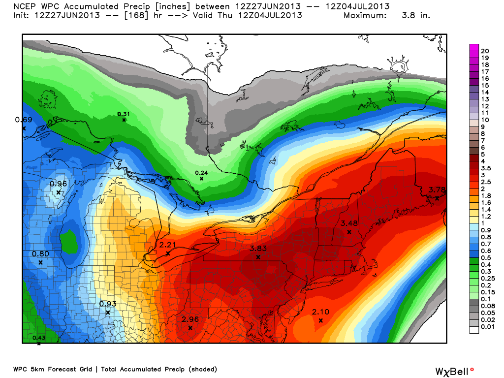
Now Through Late Next Week's Rainfall Forecast : To Be Wet
In the past few weeks, we have not had much rain across the region. In the next 7 days, several storms will give every area in the region a high chance of seeing a significant amount of rain. It's looking like the most rain will fall in Eastern Pennsylvania and Eastern New York, where around 4 - 5 total inches of rain is expected to fall in the next 7 days. In the next week, just about every other day an individual storm will arrive in the region just to soak areas that have all ready had a shower. So just how much rain are we in the northeast as a whole expecting, well here is the forecast for the next 7 day's rainfall all in one combined forecast.


Today's New Severe Thunderstorm Threats Forecast
Today will likely be the worst day of the week when it comes in terms of strong to severe thunderstorms. There will likely be widespread thunderstorms especially in New York and Pennsylvania. The storms could pack damaging winds and very heavy downpours. Here is the updated forecast for the t-storm threats index.


Wednesday, June 26, 2013
Wednesday's Updated Severe Thunerstorm Index
The threat today will be the smallest of the week overall. Isolated strong storms could be upon some areas but no real widespread severe t-storm threat is expected. But stay right here to Northeast Weather Action because it is looking like tomorrow and Friday could hold significant threats for severe thunderstorms! Here is today's updated severe thunderstorm index.


Tuesday, June 25, 2013
Today's Updated Severe Thunerstorm Threats Index
Today is going to have the same general threats as yesterday, but possibly an elevated threat level in some areas. Thunderstorms today are looking to be just as widespread as yesterday packing the threats of damaging winds, small hail, and cloud to ground lightning. The chance of tornadoes today is very low. The rest of the week could hold even higher probabilities for strong to severe thunderstorms so make sure you stay right here at Northeast Weather Action for the latest forecasts and updates, as there will be many. Here is today's updated severe thunderstorms threats index. Stay safe and have a great rest of your Tuesday!


Severe Thunderstorm Watch Could Be Issued
| Mesoscale Discussion 1218 | |
| < Previous MD Next MD > | |
 | |
| |
Monday, June 24, 2013
Tomorrow's Beach Forecasts
Tuesday should be a pretty nice day for our regions beaches. Overall mostly sunny skies will be the ruler with some very isolated thunderstorms, that if happen will not ruin your beach day! Have a great Tuesday and stay right here for the latest severe thunderstorm updates, here are the forecasts!


Severe Thunderstorm Watch Area Reduced
Not current radar, graphic only provided to express reduction of the severe thunderstorm watch box coverage.


Sunday, June 23, 2013
Monday - Wednesday Severe Thunderstorm Threats Forecast
The chance is there for strong to severe thunderstorms because of the hot and humid air. These factors will provide instability in the atmosphere and flare up thunderstorms. The threat is not all that big and the thunderstorms will not be that widespread. Here is the forecast for tomorrow through Wednesday.


Possible Severe Thunderstorm Watch To Be Issued
| Mesoscale Discussion 1186 | |
| < Previous MD | |
 | |
   MESOSCALE DISCUSSION 1186
   NWS STORM PREDICTION CENTER NORMAN OK
   1201 PM CDT SUN JUN 23 2013

   AREAS AFFECTED...SWRN THROUGH NERN NY...CNTRL VT AND NH

   CONCERNING...SEVERE POTENTIAL...WATCH POSSIBLE

   VALID 231701Z - 231900Z

   PROBABILITY OF WATCH ISSUANCE...40 PERCENT

   SUMMARY...THUNDERSTORMS ARE EXPECTED TO CONTINUE DEVELOPING THIS
   AFTERNOON FROM SWRN THROUGH ECNTRL/NERN NY INTO CNTRL VT AND NH.
   THIS ACTIVITY MAY POSE A MODEST RISK FOR MAINLY LOCALLY STRONG WIND
   GUSTS. SOME SMALL HAIL MIGHT ALSO OCCUR. OVERALL SEVERE RISK DOES
   NOT APPEAR PARTICULARLY ROBUST...SO ANY WW ISSUANCE WILL ULTIMATELY
   DEPEND ON CONVECTIVE TRENDS.

   DISCUSSION...EARLY THIS AFTERNOON STRONG DIABATIC WARMING OF THE
   MOIST BOUNDARY LAYER IS OCCURRING OVER MUCH OF NY AND SRN NEW
   ENGLAND WITH MIDDLE TO UPPER 60S DEWPOINTS AND TEMPERATURES RISING
   THROUGH THE 80S. THE LATEST ANALYSIS SHOWS MLCAPE FROM 1500-2000
   J/KG...AND CUMULUS CONGESTUS IS EVIDENT ALONG SW-NE ORIENTED CLOUD
   STREETS FROM SWRN THROUGH NCNTRL NY. CONVECTIVE INHIBITION IS
   SUFFICIENTLY WEAK AS TEMPERATURES WARM TO UPPER 80S FOR THUNDERSTORM
   INITIATION ALONG LAKE BREEZE CIRCULATIONS. THIS REGION RESIDES
   WITHIN A LOW AMPLITUDE UPPER RIDGE WITH WEAK VERTICAL SHEAR AND
   MODEST DEEP LAYER WINDS SUPPORTIVE OF MULTICELLS. THE WEAK SHEAR
   ENVIRONMENT AND WEAK MID-LEVEL LAPSE RATES MAY ULTIMATELY SERVE AS A
   LIMITING FACTOR FOR A MORE ROBUST SEVERE THREAT. HOWEVER...THE
   DESTABILIZING BOUNDARY LAYER WITH STEEPENING LOW-LEVEL LAPSE RATES
   WILL SUPPORT AT LEAST A MODEST THREAT FOR STRONG WIND
   GUSTS...ESPECIALLY IF STORMS CAN GROW UPSCALE INTO SMALL CLUSTERS OR
   LINE SEGMENTS.

   ..DIAL/KERR.. 06/23/2013


   ATTN...WFO...GYX...BTV...ALY...BGM...BUF...

   LAT...LON   42637765 43127655 43637533 44247309 44017174 43387175
               42537568 42327737 42637765
| |
Saturday, June 22, 2013
Heat Wave's Forecast Highs
Monday through Wednesday will likely be the hottest days overall throughout the area with highs topping out in the 80's and 90's region wide. Little or no rain is expected in the time period with possibly some pop-up thunderstorms because just of how hot it will be. On Thursday - Saturday, highs could still be looming around 90 from Southern Pennsylvania, and south. Here are the forecast highs for Monday - Wednesday.


Thursday, June 20, 2013
First Day Of Summer Forecast
With tomorrow being the first day of summer, now you would start to
begin to expect hot or at least warm, right. Well yes, and tomorrow you will
likely get a taste or summer, before the heat wave rolls in. Have a great
Friday and enjoy your first day of summer! I will be back to post more
articles, but for now here is tomorrow’s forecast high temperatures.

Today's Weather Forecast
With the weekend approaching. weather will be comfortable across the northeast. With highs generally in the 70's and 80's, with nothing falling from the sky, you should be good to go for all outdoor plans. Have a great day and don't forget to take advantage of today's temperatures before the heat wave rolls in! Here are today's highs . . .


Tuesday, June 18, 2013
Weekly Weather Update
Find out what kind of weather is on the way here in the Eastern US, is a heat wave on the way for the beginning of summer? Find Out Don't forget to like Northeast Weather Action on facebook!
Monday, June 17, 2013
Tomorrow's Severe T-Storm Threats
Tomorrow will definitely not pack the magnitude and widespread nature of strong and severe thunderstorms as today, but there will still be a decent threat of storms. The area with the highest threat of strong to severe thunderstorms tomorrow will be from central Ohio and into southern Pennsylvania, then sliding over to the Jersey Shore. Damaging winds and small hail could be imbeded in severe thunderstorms, so watch out for the threat of that. this forecast also has futurecast radars for those who love graphics! Stay safe and have a great evening!


Today’s Severe T-Storm Threats
It's has been several days since we have had a large scale severe weather event. But today looks to end the cold streak, with a severe thunderstorm watch already prompted across southern New England and eastern New York. With severe thunderstorms firing up, today could have more of an expected severe threat because of the original thinking, while was the majority of the action in terms of severe weather was going to stay Maryland, and to the south. Here is the new map for today's severe thunderstorm threats, and read after the map to see the descriptions of each category.


Extreme Threat: There is an 80 - 99 percent chance you will see a severe thunderstorm within 30 miles.
Significant Threat: There is a 60 - 79 percent chance you will see a severe thunderstorm within 30 miles.
High Threat: There is a 40 - 59 percent percent chance you will see a severe thunderstorm within 30 miles.
Moderate Threat: There is a 20 - 39 percent percent chance you will see a severe thunderstorm within 30 miles.
Low Threat: There is a 1 - 19 percent percent chance you will see a severe thunderstorm within 30 miles.
Subscribe to:
Posts (Atom)