
Saturday, May 18, 2013


Friday, May 17, 2013

Severe Storms On The Way For Next Tuesday - Thursday
Here in the northeast, there has not been a real widespread severe weather outbreak yet this season. But this could change heading into the middle part of next week. Originally the models were showing a major rain event, but now it looks like severe weather. Temperatures on Tuesday and Wednesday of next week will climb into the 80's from New England to Ohio. Next, there looks to be more instability in the atmosphere then originally expected. This is still far out, but looking at lots and lots of models, the area with the most extreme severe threat look to be from central Pennsylvania, down to central Virginia, and on the Delmarva. If you think you can understand model forecasts, you can see some of the models I am using in the Featured Weather Graphics page, but here is my overall forecast map for next week's severe weather outbreak. These area's wont change that much through the time leading up to the severe weather outbreak, but this is the forecast!


Thursday, May 16, 2013

Wednesday, May 15, 2013

Tuesday, May 14, 2013
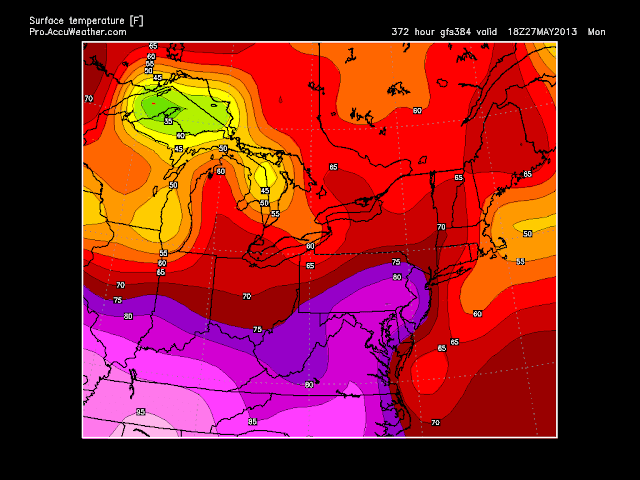
Significant Rainstorm Possible For Next Week
In some places in the northeast, a lack of rain is occurring, but could this come to an end? The answer to this question is most likely yes, because as we look to the future, many models show a significant rainstorm on the way. As you may have seen my post about the weekend severe weather threat that moves into the region by early to the middle part of next week, well many models are now indicating a low raps it's self up and slams the middle Atlantic and northeast with in some cases 6 + inches of rain. Now this is still far out, but just the amount of models jumping on this event is almost 100 %. Now the amounts of rain vary, but this storm is looking very possible, if not likely. For the time frame of this possible storm, it looks like it would impact Ohio and Kentucky on Monday night into Tuesday of next week. After that, this storm looks like it could virtually sit on areas from southern New York to central Virginia for 2 to 3 days. Models show the storm without movement from Wednesday through Saturday. In general, the spin this storm will most likely have would be just slow moving from central Virginia, through central Pennsylvania, and possibly into south central New York. Here are two models that show moisture movement six hours apart. Now the map on the top is the first six hours and the bottom model map is the next six hours.


Now as you can see, the movement of precipitation is barely anything. After that, you can see the low pressure center just spinning around in the Ohio Valley, and also the moisture intensity is very significant. Now keep in mind, these are only 12 hour rain totals and they range from 1 and a half to three inches of rain in south central New York, central Pennsylvania, central Maryland, and central Virginia. But like I said earlier, this is still very far out and this could still change because after all, this possible event is still a week away from happening. But my confidence is very high on this event already. Now going with my most recent post about the severe weather outbreak for the central and eastern US, you may be wondering if any severe weather could happen in our region. It looks like this is somewhat possible, because the temperatures look to be 5 - 10 degrees above normal during the event time period, and the instability looks to be there a little, but the volume of rain just could make this a plain heavy rain event with possibly some embedded strong / severe thunderstorms.
Going on, the totals on this rain event is probably the most uncertain factor in this storm. The models are very much in agreement that this event will happen, but the things they are not so sure about is how much rain and where could the rain fall? Well for the area that could receive the most rain, is pretty much where you see the blues on that model above. This area could move locations, but at this point, it looks like that would be the region to receive the most rainfall. Next, with some models, the stripe of heavy rain is more to the south, but with a few models, it's to the north. In my opinion, if I had to do a long range forecast on where the most precipitation could fall, I would say places from central Pennsylvania, like around Williamsport, to around the city of Richmond, Virginia. Now I will show you some model information around how much rain and where it could be. Lets start with the newest euro (ECMWF), now as you easily notice, this particular model is painting a good 5 inches of rain in areas and the models shows the storm still going on at the last available hour, hour 240, which is two Fridays from now at 8 in the morning.

To start, let me just say this model is on the higher side for how much rainfall out of the excising models. But putting that thought to the side, if this situation were to play out, wow! That would be a lot of rain, and possibly even too much to handle. Now a pretty persistent rain band would have to setup, but that is nearly impossible to forecast from this far. Now I am going to show you a different model that has a little bit of a different scenario. Here is the 00z euro, this is the morning run of the euro and it shows much less rainfall and there is not a specific area with the most heavy rain as you can see below. This could be slightly more realistic, but I actually don't see this playing out. It definitely looks like the low will swirl right into the northeast, but in my opinion it will be smaller and more effective to one specific area like what you see on the model above. But my ideas and the forecast could change completely for where the most rain falls, but maybe not. So keep track of this possible significant rainstorm and also keep up to date on the latest weather forecasts, outlooks, and a lot more weather information here at Northeast Weather Action.


Monday, May 13, 2013
Early Thoughts For The 2013 - 2014 Winter Season
As we finish up this winter and head into spring and summer, we have had everything from record warmth to frigid temperatures and intense snowstorms. Now we head into the summer in just over a month, and it's already the middle of May. So yes, we already have early thoughts on next winter. Now keep in mind, these are very preliminary thoughts and could easily be turned around completely, but this is what we think could possibly play out for the winter of 2013 - 2014. If you have heard of the ENSO, this stands for the El Nino - Southern Oscillation. To summarize this factor, waters of the western side of the South American coast fluctuate from warm to cold, if you don't know the location I am exactly talking about, here is a map showing the area.

Now that you know where this region is, lets go a little more in depth, the seas surface water temperatures dictate greatly whether an El Nino or a La Nina will occur. If the water is warm in the region, it will be an El Nino. If the water is cold, it will be an La Nina. Now you might have thought, what if the water is warm, but now that warm compared to if the water is very warm. Well if the water is barely cold or warm, it's a weak El Nino / La Nina. Now if the water were to be pretty warm, but not very warm and not barely warm, then it is called a moderate El Nino / La Nina. Lastly, if the water is very warm or cold, then a strong El Nino / La Nina will happen. These facts are the basics to learning this impotent region.
For this winter, it looks either some sort of La Nina will form, or a weak to moderate El Nino. Now how I think one of these events could happen are based on the current actions of the sea surface temperatures in this region and the model guidance for the future on this area. Now lets start with the current conditions in this region. In March through the middle of April, warm waters took over the area and formed a weak - moderate El Nino. But this didn't last long because now the warm waters are beginning to vanish from the area. Especially right around the coastal regions, the cold waters of a La Nina are starting to take over. Here is a graphic from the CPC showing the past water of the region.

Now when I look at this map, the one thing that really stands out to me is how the oranges representing the warm waters are really receding from the area close to the coast and now only the light yellow and white colors remain. After that, another thing that stands out is the warm waters off central America, this does not greatly impact the El Nino / La Nina pattern very much, but is sometimes a site with a growing La Nina. So if you were to only base your forecast on the graphic, you would most likely predict a La Nina. But this is not the only graphic that shows current information. Another is this table that represents the El Nino / La Nina movement in the past leading up to the present.


This is pretty much just showing the same information, just on a graph. The La Nina also easily seen emerging on this survey called the Anomalies. Now the last graphic I wanted to show you about current information relevant to the emerging La Nina is the very recent, weekly movement of the seas surface water temperatures. This map your about to see really shows you the cold water that is taking over the region, and could stay and build, but it also could eventually leave in time for the winter, keep in mind that it's only May, and we still have a few months until we will have a better idea for what will happen with the ENSO, so here is the graphic and then we will take about the future of the region, and I will show you a model for the El Nino / La Nina forecast.

For this outlook information, things could get a little advanced for the average person, so just hang in there. The models show a weak El Nino occurring for the first part of this winter, possibly becoming moderate in the second half of next winter. Now I don't want to get into exacts because we are so far out, but that is what the models are indicating at this point in time. Now the more known models like the ECMWF and the CMC both show a weak to moderate El Nino. But the confidence on the outlook is not great at all and this forecast has a pretty good chance of being off. If you want to see exactly where I am getting this information from, here is the graph showing the model spreadsheet. The second graphic down shows you really how much uncertainty is in this very preliminary outlook.


Another thing you can see is that the neutral winter that we just exited from will most likely not be with us next winter, and that is that thing I am most confident on. Now I know you are wondering this, what happens with an El Nino / La Nina in play, what are the effects on the US? Well because we are possibly looking at a weak to moderate El Nino, here are the effects of a weak to moderate El Nino. There is normally a high just south of Alaska that forces the jet stream north over that high and then the jet stream skips the western US and dives down into the eastern United states. Causing mild temperatures in the northwest and north central US and colder temperatures on the east coast.
After that, there is normally a region in the southwest, in California and western Arizona is wetter then normal and the southeast and east coast is also normally west. Most often, the southeast has lots of rain and the northeast is snowy because of the above average moisture on the east coast and the cold air. But if we were to have a strong El Nino, which is not likely, but there would be almost the opposite, but that is not likely to occur. Now here is a map showing the impacts on the US when there is a weak to moderate El Nino.

These thoughts are my preliminary thoughts but there is still much more to be determined like temperatures and precipitation. Once again, take this outlook with half a grain of salt because anything that I said could change, so don't plan on everything that I said playing out. I should have my next update on the winter outlook sometime in late June, which will be my preliminary 2013 - 2014 Winter Outlook, but the things you have just read are my early thoughts for the 2013 - 2014 winter season. Come back in late June for my preliminary outlook. But as always tune into Northeast Weather Action for the latest weather forecasts and outlooks. Thanks for reading!

Sunday, May 12, 2013
Long Range Lookout : When Will The Warmth Come?
As we finish a weekend which had everything but warm temperatures, you might be asking yourself and look for an answer "When will the warmth come?" Well I have the answer for you. Things will likely start to warm up by the middle of the week. Highs will likely go from 3 to even 6 degrees below average that we have been dealing with 5 to 10 degree above average weather. Also, these temperatures will most likely last pretty long, here are a few models that show the way!


So, I think this showed you the warmth is coming!
Here is a model showing Thursday's highs, the heat is starting!

Here is a model showing the future warmth, on Monday May 20th!

Lastly, you can see the warmth lasts a long time!


Subscribe to:
Posts (Atom)