

Showing posts with label WPC Weather. Show all posts
Showing posts with label WPC Weather. Show all posts
Friday, June 28, 2013
Updated 7 Day Rain Forecast - Keep The Umbrella Out
Today and tomorrow will feature showers around the area with some heavier rain perhaps hanging around in New England. From Sunday into the majority of next week, several low pressure systems will produce significant amounts of rain throughout the region. So keep the umbrella out because you will need it again. With everything said, here is the precipitation forecast for the next 7 days. More rain is coming so as always stay right here at Northeast Weather Action for the latest weather forecast and updates! Have a great weekend!

Today's Severe Thunderstorms Threats - Nothing Like Yesterday
Today there will be some isolated strong thunderstorms, but mainly more shower activity and a few embedded storms. Yesterday we had many flash flood warnings and several severe thunderstorm warnings, as well as even a few tornadoes in Pennsylvania. But that was yesterday, today is not expected to be anything close to that magnitude.
Overall there is a low threat of strong to severe storms across the region with a moderate threat which is still not noticeable, in New Jersey and on the Del-Mar-Va. This is the area where some wind damage in storms are possible. So you don't have much to worry about when going to outdoor activities. Here is today's severe thunderstorm threats forecast, have a great day and stay tuned to Northeast Weather Action for the latest forecasts and updates on all northeast weather action!

Overall there is a low threat of strong to severe storms across the region with a moderate threat which is still not noticeable, in New Jersey and on the Del-Mar-Va. This is the area where some wind damage in storms are possible. So you don't have much to worry about when going to outdoor activities. Here is today's severe thunderstorm threats forecast, have a great day and stay tuned to Northeast Weather Action for the latest forecasts and updates on all northeast weather action!

Thursday, June 27, 2013
Full Weekend Weather Forecast
As far as weather conditions go, isolated thunderstorms with some rain showers in Northern Maine. Temperatures should be in the 70's and 80's widespread throughout the region.


Next Week's (June 30th - July 6th) Daytime Highs Forecast
The temperatures during the daytime next week will be generally the same every day of the week. Highs should be in the 70's and 80's region wide with possibly some upper 60's in northern Maine.


Now Through Late Next Week's Rainfall Forecast : To Be Wet
In the past few weeks, we have not had much rain across the region. In the next 7 days, several storms will give every area in the region a high chance of seeing a significant amount of rain. It's looking like the most rain will fall in Eastern Pennsylvania and Eastern New York, where around 4 - 5 total inches of rain is expected to fall in the next 7 days. In the next week, just about every other day an individual storm will arrive in the region just to soak areas that have all ready had a shower. So just how much rain are we in the northeast as a whole expecting, well here is the forecast for the next 7 day's rainfall all in one combined forecast.


Today's New Severe Thunderstorm Threats Forecast
Today will likely be the worst day of the week when it comes in terms of strong to severe thunderstorms. There will likely be widespread thunderstorms especially in New York and Pennsylvania. The storms could pack damaging winds and very heavy downpours. Here is the updated forecast for the t-storm threats index.


Wednesday, June 26, 2013
Weekly Weather Update: Rainy Weather Is Down The Pipeline! See When and How Much!
I take you through a few models to express the significant amounts of rain on the way for the northeast. We also take a quick look at the temperatures and overall the next 10 days in weather. Don't forget to like Northeast Weather Action on facebook!
Monday, June 24, 2013
Tomorrow's Beach Forecasts
Tuesday should be a pretty nice day for our regions beaches. Overall mostly sunny skies will be the ruler with some very isolated thunderstorms, that if happen will not ruin your beach day! Have a great Tuesday and stay right here for the latest severe thunderstorm updates, here are the forecasts!


Sunday, June 23, 2013
Possible Severe Thunderstorm Watch To Be Issued
| Mesoscale Discussion 1186 | |
| < Previous MD | |
 | |
   MESOSCALE DISCUSSION 1186
   NWS STORM PREDICTION CENTER NORMAN OK
   1201 PM CDT SUN JUN 23 2013

   AREAS AFFECTED...SWRN THROUGH NERN NY...CNTRL VT AND NH

   CONCERNING...SEVERE POTENTIAL...WATCH POSSIBLE

   VALID 231701Z - 231900Z

   PROBABILITY OF WATCH ISSUANCE...40 PERCENT

   SUMMARY...THUNDERSTORMS ARE EXPECTED TO CONTINUE DEVELOPING THIS
   AFTERNOON FROM SWRN THROUGH ECNTRL/NERN NY INTO CNTRL VT AND NH.
   THIS ACTIVITY MAY POSE A MODEST RISK FOR MAINLY LOCALLY STRONG WIND
   GUSTS. SOME SMALL HAIL MIGHT ALSO OCCUR. OVERALL SEVERE RISK DOES
   NOT APPEAR PARTICULARLY ROBUST...SO ANY WW ISSUANCE WILL ULTIMATELY
   DEPEND ON CONVECTIVE TRENDS.

   DISCUSSION...EARLY THIS AFTERNOON STRONG DIABATIC WARMING OF THE
   MOIST BOUNDARY LAYER IS OCCURRING OVER MUCH OF NY AND SRN NEW
   ENGLAND WITH MIDDLE TO UPPER 60S DEWPOINTS AND TEMPERATURES RISING
   THROUGH THE 80S. THE LATEST ANALYSIS SHOWS MLCAPE FROM 1500-2000
   J/KG...AND CUMULUS CONGESTUS IS EVIDENT ALONG SW-NE ORIENTED CLOUD
   STREETS FROM SWRN THROUGH NCNTRL NY. CONVECTIVE INHIBITION IS
   SUFFICIENTLY WEAK AS TEMPERATURES WARM TO UPPER 80S FOR THUNDERSTORM
   INITIATION ALONG LAKE BREEZE CIRCULATIONS. THIS REGION RESIDES
   WITHIN A LOW AMPLITUDE UPPER RIDGE WITH WEAK VERTICAL SHEAR AND
   MODEST DEEP LAYER WINDS SUPPORTIVE OF MULTICELLS. THE WEAK SHEAR
   ENVIRONMENT AND WEAK MID-LEVEL LAPSE RATES MAY ULTIMATELY SERVE AS A
   LIMITING FACTOR FOR A MORE ROBUST SEVERE THREAT. HOWEVER...THE
   DESTABILIZING BOUNDARY LAYER WITH STEEPENING LOW-LEVEL LAPSE RATES
   WILL SUPPORT AT LEAST A MODEST THREAT FOR STRONG WIND
   GUSTS...ESPECIALLY IF STORMS CAN GROW UPSCALE INTO SMALL CLUSTERS OR
   LINE SEGMENTS.

   ..DIAL/KERR.. 06/23/2013


   ATTN...WFO...GYX...BTV...ALY...BGM...BUF...

   LAT...LON   42637765 43127655 43637533 44247309 44017174 43387175
               42537568 42327737 42637765
| |
Friday, June 21, 2013
Long Range Lookout: What Will The Weather Be Like After The Heat Wave? Find Out!
I'm sure by now you must of heard about the upcoming heat wave that will be sitting on the northeast. After that, little to no precipitation is expected to fall during this period, which could force you to use those sprinklers. But after the heat wave, what comes next? Well there are various answers to that question and so lets get started. The start of the long range lookout obviously starts after the heat wave passes on by. So lets use the golden tool to get the answer to that question, weather models. Lets start with the ecmwf model, or what we like to call the euro model. The euro model indicates a wetter and more active pattern along with below normal temperatures for this time of year starting the later part of next week. It shows storms one after another impacting nearly the same areas with rainstorms and overall has the whole region is below average in terms of temperatures.


I would think you might want to figure out that area that could possibly receive significant amounts of rain. Well this region sits anywhere from Northern Ohio, through Western New York, and almost all of the state of Pennsylvania. Keep in mind, this area could easily be bumped around and that nothing is nailed in stone, or guaranteed yet. This like I said would be late next week, but the below normal temperatures wouldn't set in until about the weekend before the 4th of July. But lets get back to the precipitation part of this event and then later I will go more into detail about the upcoming temperatures. So going back to the models and how they continue to like a certain region to get the most rainfall. Here is the second rainstorm out of the two on the euro model.

You can really see both storms pretty good in this model. First you see the exiting storm off of the Southern New England - Long Island Coastline. After that the second storm is mainly in Pennsylvania and about to enter New Jersey. Next you also notice Western New York receiving rain. Generally a good 1 to 2 inches of rain are possible from both storms combined anywhere from Central and Southern New Jersey, into all of Pennsylvania, as well as Northern Ohio and Western New York. And then around a half an inch to and inch of rain is looking likely from Northern New Jersey, down onto the Del-Mar-Va and into Maryland, through West Virginia. So that is the story for the precipitation side of things, now lets get to the temperatures that are looking likely after this heat wave.
By two weekends from now, cooler temperatures, mainly in the 60's and 70's will set in across the northeast. What is looking like to play it is a trough from Ontario up in Canada will likely dive south into the Great Lakes and northeast, reducing the temperatures significantly. In a way just kicking the heat out the door, or shoving back into the southeast US. Temperatures will likely range from the mid to upper 60's in Northern New England and Northern New York, and then lower 70's across Central and Southern New England, as well as Central and Southern, as well as Western New York. After that lower to mid 70's are expected to occur from the Appalachian Mountains in Western and Central Pennsylvania, to the Poconos. Lastly the mid to upper 70's are looking most likely in all of New Jersey, and on into Eastern PA and the Del-Mar-Va. Here is what I am describing in a map form, from the euro model.

Now this map could be under-doing the temperatures just a little, as the euro usually does. But I think overall you can kind of get the sense that cooler temperatures are on the way, but first we have to get through the heat wave. Now I keep on saying adjectives like cooler, and below normal. I really want to make you second guess those words because I said this a few weeks ago and to me, it almost sounds like I am saying it's going to be so cold you are going to need jackets. No, what I am trying to say is cooler than average temperatures are coming, out normals this time of year range from the mid 80's to the low 70's, of course depending on where you are located. After that, we have no good idea on how long these below normal temperatures are going to last, so don't get out of that summer mood! Thank you for reading and be sure to stay tuned to Northeast Weather Action for the latest weather forecasts and updates! Have a great weekend and enjoy that pool next week!
Monday, June 17, 2013
Tomorrow's Severe T-Storm Threats
Tomorrow will definitely not pack the magnitude and widespread nature of strong and severe thunderstorms as today, but there will still be a decent threat of storms. The area with the highest threat of strong to severe thunderstorms tomorrow will be from central Ohio and into southern Pennsylvania, then sliding over to the Jersey Shore. Damaging winds and small hail could be imbeded in severe thunderstorms, so watch out for the threat of that. this forecast also has futurecast radars for those who love graphics! Stay safe and have a great evening!


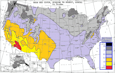
So How Cloudy Is The Northeast Compared To The Rest Of The US? Find Out!
This is a question you may have asked yourself many times when a cloudy and gloomy day is upon you. So here are the real answers to the interesting question. I found this dusty old NOAA chart from almost 20 years ago that likely has then answer. This map was generated by sunshine sensors which are located at almost every observations location. To summarize, it looks like our region here in the northeast is one of the cloudier areas across the country. Where mountain ranges are really determine the amount of sunshine, as you can clearly see for example the Appalachian Mountains in eastern West Virginia. But in the desert southwest, only around 3 out of 10 days have clouds in the sky. But in the Pacific Northwest, 8 out of every 10 days are cloudy. After that, storm tracks have to do somewhat with this forecast, because we see many storms here in the northeast and Great Lakes, more cloudy days are the result.


Here is the annual average amounts of precipitation across the lower 48, and as you can see, this map is somewhat coordinated with the map above.

Saturday, June 15, 2013
Sunday - Monday WPC Total Precipitation Forecast
As if we need more rain, but don't worry, this event is not going to be like the latest rainstorms we have just had. The rain from this event will be centered in Western new York, where there will be straight rain, and into New England. But as you head into Ohio, PA, and into New Jersey, you run the risk for strong and/or severe storms.

Thursday, June 13, 2013
Tomorrow 12 AM – Friday 10 AM Final Rainfall Forecast
Here are the final thoughts on rainfall coming early tomorrow morning through around 10 AM Friday and also the updated rainfall totals forecast from the Weather Prediction Center.


Wednesday, June 12, 2013
New Rainfall Forecast From Tonight - Friday Afternoon
Here is the updated rainfall forecast for tonight through Friday Afternoon, stay dry!


Tuesday, June 11, 2013
New Thoughts On Wednesday Night - Friday Morning Rain Event
Yesterday parts of the region received moderate rain all day, like in New England. Meanwhile other sections of the region like Northern Maryland, dealt with tornadoes. Today scattered showers and thunderstorms will be throughout the area. Don't forget about last week's rain from what was Tropical Storm Andrea, or the remnants of it. So with all of this rain, can we possibly expect more. After all, cities like New York City are having one of the top 10 wettest June's of all time, and we are only a third of the way into the month.


This answer to the previous question is yes, do to the active pattern that is constantly tracking storms through the Midwest and Ohio Valley, straight into the Northeast. Now lets get to details on this rainstorm. Showers and thunderstorms Wednesday afternoon across Western PA and New York, as well as Central and Northern Ohio could be severe, with possibly a derecho, which is a long line of severe thunderstorms that cause widespread amounts of damage. This name might seem very familiar to you. It would at around this time last year, two derechos swept through Ohio and from Harrisburg, PA to Richmond, Virginia. These prompted long lasting power outages. Which did not mix the the heat wave we experienced shortly after derechos.
After Wednesday, a low pressure system will approach the region Thursday Morning, shortly after, still likely during Thursday Morning, the storm system will push into Northern Ohio and into Western PA. Heavy is likely to fall, especially on the northern side of the system, which is being indicated on the new models. This. is causing the forecast to change drastically and could still go either way, and could just be a trend that could change. After the rainfall moves into Western PA and Western New York, it will move into Eastern New York as well as Central and Eastern Pennsylvania by around the early afternoon hours on Thursday.
The system is actually looking pretty intense, being forecasted a 997 MB storm in Southeastern PA. When Friday Morning rolls around, the area of low pressure will likely be around Long Island, or just south of it. The rain extent should reach up through Southern New England and into Central New England. Now the southern end of the rain is still more out there, or unknown. On the model I am about to show you, you will see what I am talking about. Here is the new 00z GFS for late Thursday Night, with the low centered in Southeastern PA.

As you can see, it's clear the majority of the rainfall produced by this storm in on the northern side of the system. This is the variable that still has many possibilities but is now becoming more certain. Many models are now showing this solution, so the forecast has changed greatly and looks to be holding throughout the most recent model forecasts. Keep tuned into Northeast Weather Action for the latest rainfall forecasts on this storm. Also stay here because many more storms are coming our way, take my word when I say that. For now I will leave you with the new rainfall forecast for Wednesday Night through Friday at around of just before noon. Thanks for reading!

Sunday, June 9, 2013


This Evening - Tuesday Night Final Rainfall Totals Forecast

Here is the final forecast for rainfall totals expected from tonight trough Tuesday Night. This is now looking like it will be a heavy rain event with minor flooding possible around creeks and streams. As well as urban and suburban street flooding. The heaviest rainfall is expected to fall in southwestern New England and int Southeastern New York. Sorry but it looks like tomorrow will be a day to forget about for summer lovers and possibly as well as Tuesday, especially in Northern New Jersey into Southern New England. Stay tuned to Northeast Weather Action for the latest alerts on this storm as well as forecasts for the many more rainy times we will have in the next several weeks!
Subscribe to:
Posts (Atom)