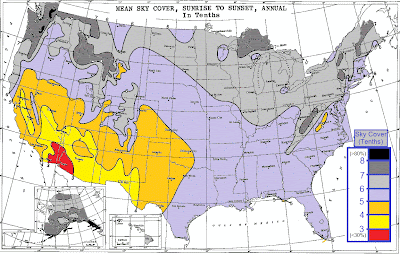
This is a question you may have asked yourself many times when a cloudy and gloomy day is upon you. So here are the real answers to the interesting question. I found this dusty old NOAA chart from almost 20 years ago that likely has then answer. This map was generated by sunshine sensors which are located at almost every observations location. To summarize, it looks like our region here in the northeast is one of the cloudier areas across the country. Where mountain ranges are really determine the amount of sunshine, as you can clearly see for example the Appalachian Mountains in eastern West Virginia. But in the desert southwest, only around 3 out of 10 days have clouds in the sky. But in the Pacific Northwest, 8 out of every 10 days are cloudy. After that, storm tracks have to do somewhat with this forecast, because we see many storms here in the northeast and Great Lakes, more cloudy days are the result.
Here is the annual average amounts of precipitation across the lower 48, and as you can see, this map is somewhat coordinated with the map above.


No comments:
Post a Comment
What do you think about this article? No spam tolerated.