As severe weather is beginning to become more common throughout the area, the title of the article may not shock you. Yes, another severe weather outbreak looks to be coming through the pipeline for Sunday, into Sunday night. The models are mainly in agreement except for the morning Euro that only shows the severe weather in one specific area, which looks to be off. But all other models are in agreement that a decent size severe weather event will take place.
To start off, lets look at some factors that are going into my thinking. The first one if the cape, which looks to be favorable for severe thunderstorms on Sunday into Sunday night, so that variable is more towards a more severe weather. The next variable is the temperatures. Now right now, it is scorching outside with temperatures will above average and more summer-like. Well the temperatures look to stay this way into Sunday, with the lows Sunday night only in the 60's. But that's before the cold front moves through, which is one of the factors that will be mentioned.
The next factor will be when the cold front moves though. After the cold front passes, the severe threat will decrease, so depending on when the cold front moves through the area is will affect the timings. After that, the last big factor is the amount of moisture. But the supply of moisture for thunderstorms to use up looks very large on Sunday into Sunday night, as in some areas, mainly across the northern region of the area, some heavy rain could just fall. So these are the general factors that are going into this forecast and this possible outbreak. Now lets look at some weather models and see what they indicate, and then I will show you all my forecast map, which could possibly change, but for now, here are the models and my forecast.
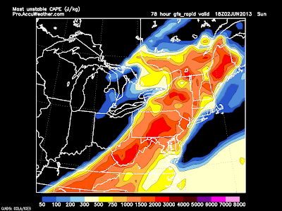
So lets start with the GFS model, here is the 12z GFS at hour 78, which is Sunday at 2:00 PM.
As you can see, the model is hinting at something. What it's hinting at is severe weather, as you most likely could have guessed. So let me summarize the model. It's showing severe weather from West Virginia to northern New York. The red in Maine is seen almost everyday somewhere. But the main event is from northern New York to southern Pennsylvania. But the area most prone to storms in the event will be from southern PA to central New York. There will likely be several severe thunderstorms and possibly a few tornadoes. Now here is the euro model for Sunday night at 8 PM.
The euro model really shows it's average northeastern US night based outbreak. It once again shows severe weather in southern Pennsylvania, through northeastern PA. So with all of the factors going into my forecast, here is my forecast idea for this event. Thanks for reading and be sure to stay here at Northeast Weather action for the latest forecasts and outlooks for this event and all other weather events here in the northeast.
Article posted at 4:42 PM EST.


No comments:
Post a Comment
What do you think about this article? No spam tolerated.