
At this time of year this question is on people's minds and many people don't really know the answer. So we have seen some severe weather so far this year, here in the northeast US, but it's only April. Now as you may have seen on places like The Weather Channel that the month of May is the most active time of year for severe weather, but don't let that fool you, because that's just when in the US severe weather is the most widespread, but in our neck of the woods, this is not true. So lets move on from where we are right now. In late April, you can see some spotty severe weather action in the southern areas of the northeast US, but the overall threat for severe weather and tornadoes is very low and nearly no threat exists for places like Maine. Here is a map provided by The Weather Channel showing the risks for tornadoes and severe weather for the month of April.
April:

May:
After that comes May, this is when the temperatures begin to quickly rise across the northeast and the risk of severe weather also increases. There is typically one or two severe weather outbreaks containing about 20 or 30 severe thunderstorms each that impact the northeast in May, but the risk for severe weather almost everyday in some places has not arrived yet. Really May is spread out, in early May, things are normally pretty quiet in terms of severe weather, but as the month moves on, the chance for severe weather almost doubles. By the middle part of May, severe weather most of the time of just about upon us and most of the time becomes more noticeable, whether people see events or damage from or about severe weather say in the southeast US or the plain states. Going on, by late May, severe weather has arrived, especially in areas like Ohio, West Virginia, Maryland, and Pennsylvania. Here is a map provided by The Weather Channel showing the risks for tornadoes and severe weather for the month of May.
May:

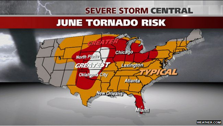
June:
During late May and early June, there are normally not many tornadoes around are area but there certainly are severe thunderstorms. After that time period, in the middle part of June, the risk of severe weather runs up further into the northeast as now we start to get New Jersey, New York, and all of New England involved in the fun. Now in late June, the risk of tornadoes is on the increase because of the still rising temperatures and the more warm and live gulf moisture combined with sometimes harsh cold fronts, most of the time in this part of the year make for a very good severe weather outbreak setup. The risk for everything from tornadoes to strong storms to hurricanes is upon us by late June as the summer heat is on high. Here is a map provided by The Weather Channel showing the risks for tornadoes and severe weather for the month of June.
June:
July:
Now moving into the Month of July, this is the month when the most severe weather and tornadoes strike the northern US. Normally the whole month is packed with severe weather and the risk in some spots for severe weather almost every day. This is also the month with the hottest normal high temperatures across the region. After that we have to deal with the rising threat for tropical storms or hurricanes that could effect the area, and as we know, severe weather comes with tropical cyclones, now normally if there are tornadoes connected to a tropical cyclone, they are weak and short lasting, but overall the month of July is the answer of the title question. But this will be typical and nothing we have not ever seen before. Here is a map provided by The Weather Channel showing the risks for tornadoes and severe weather for the month of July.
July:

August:
For the month of August, the schedule is very spread out for severe weather events. In the beginning of August, the risk for severe weather and tornadoes is still out there and moderate. Now as we work our way into the month, the threat for severe weather begins to sag out of New England and northern New York, now very much contained to central New York, as almost like now if you were to bring up a map and draw a line from Boston to Syracuse, normally places south of this line still have a risk for severe weather in the middle part of August, but areas north of that line begin to yes, already prepare for the cold air of fall.
But the story is completely different for locations south of that line, really in Pennsylvania and Ohio, as well as West Virginia, Virginia, Maryland, and Delaware. For these places the threat for severe weather is growing lower and lower, but still there. But when is comes in terms of tornadoes, this risk is very low by late August pretty much everywhere in the northeast. Here is a map provided by The Weather Channel showing the risks for tornadoes and severe weather for the month of August.
August:

September:
In September, the risk of severe weather is really rapping up and even though there is still some risks for severe weather, the risk for severe weather in September is about the same as the risk for severe weather is early May, which is not all that great. At this time of the year, the topic in weather for the northeast really switches from severe weather to tropical storms and hurricanes, which as we know can still cause severe weather, but like I said, the severe storms are normally very scattered and mainly for damaging winds produced by the actual tropical cyclone, and also the tornadoes that are produced in tropical storms and hurricanes are very weak and short lasting, most of the time not even touching the ground. So overall in September, this risk for severe weather and tornadoes greatly decreases. Here is a map provided by The Weather Channel showing the risks for tornadoes and severe weather for the month of September.
September:

Thanks for reading and be sure to take a look below at my Official 2013 Summer Severe Weather Outlook!
My Official 2013 Summer Severe Weather Outlook
As we are about to enter the time of year with lots of severe weather here in the northeast, I wanted to present my Official 2013 Summer Severe Weather Outlook. This outlook will be short and to the point. Overall I predict a slightly above average severe weather season for the northeast this year. I really think this because the amount of gulf moisture that will fuel severe weather outbreaks this year will be around average because of the the slightly above average warm waters of the gulf as seen in the upper right hand corner of this graphic.

Also as you can see on the model below ,the JAMSTEC shows warmer gulf waters that will feed warm and moist gulf air and moisture into cold fronts, providing possible slightly more or widespread severe weather events.

So with these factors in mind as well as others, below is my Official 2013 Summer Severe Weather Outlook, thanks for reading!

Greate post. Keep posting such kind of info on your blog.
ReplyDeleteIm really impressed by it.
Hi there, You have done a fantastic job. I'll certainly digg it and individually suggest to my friends. I am confident they'll be benefited from this site.
Take a look at my homepage ... calories walking calculator