Showing posts with label Temperature Weather. Show all posts

Friday, June 21, 2013

Long Range Lookout: What Will The Weather Be Like After The Heat Wave? Find Out!

          I'm sure by now you must of heard about the upcoming heat wave that will be sitting on the northeast. After that, little to no precipitation is expected to fall during this period, which could force you to use those sprinklers. But after the heat wave, what comes next? Well there are various answers to that question and so lets get started. The start of the long range lookout obviously starts after the heat wave passes on by. So lets use the golden tool to get the answer to that question, weather models. Lets start with the ecmwf model, or what we like to call the euro model. The euro model indicates a wetter and more active pattern along with below normal temperatures for this time of year starting the later part of next week. It shows storms one after another impacting nearly the same areas with rainstorms and overall has the whole region is below average in terms of temperatures.

          I would think you might want to figure out that area that could possibly receive significant amounts of rain. Well this region sits anywhere from Northern Ohio, through Western New York, and almost all of the state of Pennsylvania. Keep in mind, this area could easily be bumped around and that nothing is nailed in stone, or guaranteed yet. This like I said would be late next week, but the below normal temperatures wouldn't set in until about the weekend before the 4th of July. But lets get back to the precipitation part of this event and then later I will go more into detail about the upcoming temperatures. So going back to the models and how they continue to like a certain region to get the most rainfall. Here is the second rainstorm out of the two on the euro model.


          You can really see both storms pretty good in this model. First you see the exiting storm off of the Southern New England - Long Island Coastline. After that the second storm is mainly in Pennsylvania and about to enter New Jersey. Next you also notice Western New York receiving rain. Generally a good 1 to 2 inches of rain are possible from both storms combined anywhere from Central and Southern New Jersey, into all of Pennsylvania, as well as Northern Ohio and Western New York. And then around a half an inch to and inch of rain is looking likely from Northern New Jersey, down onto the Del-Mar-Va and into Maryland, through West Virginia. So that is the story for the precipitation side of things, now lets get to the temperatures that are looking likely after this heat wave.

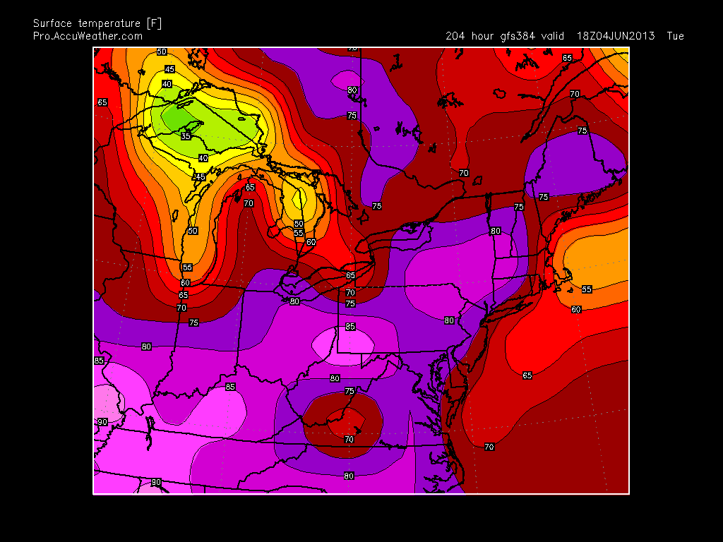
          By two weekends from now, cooler temperatures, mainly in the 60's and 70's will set in across the northeast. What is looking like to play it is a trough from Ontario up in Canada will likely dive south into the Great Lakes and northeast, reducing the temperatures significantly. In a way just kicking the heat out the door, or shoving back into the southeast US. Temperatures will likely range from the mid to upper 60's in Northern New England and Northern New York, and then lower 70's across Central and Southern New England, as well as Central and Southern, as well as Western New York. After that lower to mid 70's are expected to occur from the Appalachian Mountains in Western and Central Pennsylvania, to the Poconos. Lastly the mid to upper 70's are looking most likely in all of New Jersey, and on into Eastern PA and the Del-Mar-Va. Here is what I am describing in a map form, from the euro model.


          Now this map could be under-doing the temperatures just a little, as the euro usually does. But I think overall you can kind of get the sense that cooler temperatures are on the way, but first we have to get through the heat wave. Now I keep on saying adjectives like cooler, and below normal. I really want to make you second guess those words because I said this a few weeks ago and to me, it almost sounds like I am saying it's going to be so cold you are going to need jackets. No, what I am trying to say is cooler than average temperatures are coming, out normals this time of year range from the mid 80's to the low 70's, of course depending on where you are located. After that, we have no good idea on how long these below normal temperatures are going to last, so don't get out of that summer mood! Thank you for reading and be sure to stay tuned to Northeast Weather Action for the latest weather forecasts and updates! Have a great weekend and enjoy that pool next week! 

Thursday, June 13, 2013

Saturday's Temperatures and Weather Forecast

          The first part of your weekend is looking great with widespread 60's and 70's with great weather conditions!


Tuesday, June 11, 2013

New Thoughts On Wednesday Night - Friday Morning Rain Event

          Yesterday parts of the region received moderate rain all day, like in New England. Meanwhile other sections of the region like Northern Maryland, dealt with tornadoes. Today scattered showers and thunderstorms will be throughout the area. Don't forget about last week's rain from what was Tropical Storm Andrea, or the remnants of it. So with all of this rain, can we possibly expect more. After all, cities like New York City are having one of the top 10 wettest June's of all time, and we are only a third of the way into the month.

          This answer to the previous question is yes, do to the active pattern that is constantly tracking storms through the Midwest and Ohio Valley, straight into the Northeast. Now lets get to details on this rainstorm. Showers and thunderstorms Wednesday afternoon across Western PA and New York, as well as Central and Northern Ohio could be severe, with possibly a derecho, which is a long line of severe thunderstorms that cause widespread amounts of damage. This name might seem very familiar to you. It would at around this time last year, two derechos swept through Ohio and from Harrisburg, PA to Richmond, Virginia. These prompted long lasting power outages. Which did not mix the the heat wave we experienced shortly after derechos.

          After Wednesday, a low pressure system will approach the region Thursday Morning, shortly after, still likely during Thursday Morning, the storm system will push into Northern Ohio and into Western PA. Heavy is likely to fall, especially on the northern side of the system, which is being indicated on the new models. This. is causing the forecast to change drastically and could still go either way, and could just be a trend that could change. After the rainfall moves into Western PA and Western New York, it will move into Eastern New York as well as Central and Eastern Pennsylvania by around the early afternoon hours on Thursday. 

          The system is actually looking pretty intense, being forecasted a 997 MB storm in Southeastern PA. When Friday Morning rolls around, the area of low pressure will likely be around Long Island, or just south of it. The rain extent should reach up through Southern New England and into Central New England. Now the southern end of the rain is still more out there, or unknown. On the model I am about to show you, you will see what I am talking about. Here is the new 00z GFS for late Thursday Night, with the low centered in Southeastern PA.


          As you can see, it's clear the majority of the rainfall produced by this storm in on the northern side of the system. This is the variable that still has many possibilities but is now becoming more certain. Many models are now showing this solution, so the forecast has changed greatly and looks to be holding throughout the most recent model forecasts. Keep tuned into Northeast Weather Action for the latest rainfall forecasts on this storm. Also stay here because many more storms are coming our way, take my word when I say that. For now I will leave you with the new rainfall forecast for Wednesday Night through Friday at around of just before noon. Thanks for reading!


Monday, June 3, 2013

Potential Severe Thunderstorm Watch To Be Issued


          The Storm Prediction Center is currently monitoring this area and questioning whether or not to issue a Severe Thunderstorm Watch. Storms are currently firing up in this region and could turn severe. Although a Severe Thunderstorm Watch will most likely not be issued, keep a look out for potential severe and strong storms around this region.

Monday, May 27, 2013

Will It Be Cold Or Warm After Heat Wave? Find Out!

          I have talked and posted a lot about the heat wave that s coming from the middle of this week through Sunday, but never talked spoke about what is coming after the heat. Well it looks like summer - like temperatures will continue after this event. I am mainly using the models to be able to say this information because they are all very confident that temperatures after the heat wave will remain 5 - 10 degrees above average. The main reason the reason this heat wave will end is because of a cold front that will pass through the region next Monday. But going back to how I use the models, for example one model I like to use is the GFS, so here is a model I selected from the GFS which shows temperatures 204 hours out, which is next Tuesday afternoon, after the heat wave ends.


          Now as you can clearly see, the summer warmth will not fully exit. Temperatures will likely stay in the 70's from Maine to Massachusetts, and then from Connecticut south, the low 80's could hang around. Temperatures this time of year should be anywhere from the high 70's in southern Pennsylvania to the low 70's in southern New Hampshire. So overall, the GFS has the temperatures staying around 5 degrees above average. Now here is a ECMWF model, which shows a slightly different situation setting up after the heat wave.


          Really, the 12Z euro shows around average to even slightly below average temperatures after the heat wave. This particular model shows temperatures at the height of the day on June 6th. But temperatures on the euro are not the much cooler. To summarize the euro, temperatures will stay around average after the heat wave, and then the confidence after about June 6th in temperatures go down. The last thing I wanted to show is the Climate Prediction Center's 8 - 14 day temperature outlook, here is their forecast.


          With the CPC's forecast, they have almost the whole nation in above average temperatures, but the farthest above normal temperatures are expected to be located in the northeast. So the warmth will certainly not leave after the heat wave does on Sunday. Thanks for reading and be sure to tune into Northeast Weather Action to keep updated on this event and many other weather forecasts and outlooks that come out, stay safe!

Heat Is On The Way!


Updated Tuesday - Wednesday Severe Threats

          As for last week when we had a three day long severe weather outbreak with tornadoes here in the northeast, this severe weather event will not be nearly as intense or as widespread as the severe weather last week. Like I said, as supposed to last weeks severe event, models have this event being a mainly southern New York state, south event. This is mainly because of the temperatures and cloud cover, causing the cape and instability to not be favorable for severe thunderstorms to flare up across areas like New England and Syracuse, New York, north on Tuesday. Now there is one area in and around the Ohio Great Lakes region, connecting the the Midwest severe weather that will be more significant, causing the forecast to have that area. So overall Tuesday will not be the biggest day we have ever seen, as will Wednesday not be. Here is Tuesday's Severe Threat index, then the updated Storm Prediction Center probabilities forecast, followed be a future radar model from the 00z NAM run.


          Now really, the same information applies for Wednesday, everything except the heat! On Wednesday, the heat will be turned on, as will many people will turn the AC on. On Wednesday, the thunderstorms will be scattered and very isolated across the area. Although, the threat really moves to the New Jersey and New England area because as does the majority of the precipitation. Below is the Wednesday's Severe Threat Index forecast. Thanks for reading and tune into Northeast Weather Action for weather forecast, predictions, and much more weather related information, thank you!


Friday, May 24, 2013

Memorial Day Weekend Weather Summary

          This weekend will be generally normal, with slightly below average temperatures. First lets start with today, today will feature some clouds and even rain showers in the morning around the region especially in New England, eventually fading into mostly sunny skies region wide, except in New England where the showers will continue, with temperatures falling to near 40 degrees by tomorrow evening around New England. The temperatures across the area should be below normal for the first day of the Memorial Day Weekend, with temperatures anywhere from five degrees below normal in Pennsylvania to 25 degrees below normal in New England. But don't let this forecast keep you away from the grill because these temperatures will warm up by Sunday and Monday.

          On Sunday, the weather should clear out for the most part, but some morning showers in New England are possible. Otherwise the region will be mainly dry with sunny skies from New York, into Pennsylvania. The temperatures will rebound slightly with conditions warming close to 70 in Pennsylvania to the low to middle 60's in New England, which is a big improvement from highs in the lower 50's on Saturday. Overall the temperatures on Sunday should be around 5 - 10 degrees below average region wide, but the sunny skies that will shine in New York and Pennsylvania will make it feel warmer than it actually will be. So now we can start cooking the hot dogs and hamburgers. But you probably won't want to get in the pools just yet!

          For Memorial Day, temperatures will most likely go back to what we would expect for this time of year. The Weather should be precipitation free for almost all of the region with some scattered rain drops in down east Maine. But for most likely everywhere else, sunny skies should prevail. Now you can have a great time outside, with cold days just before, there may be slightly less bugs out there also, so your in good shape for the Memorial Day Holiday. Thanks for reading and keep here at Northeast Weather Action for all weather related forecasts and predictions, as well as updates and great maps! Have a great three day weekend!


Thursday, May 23, 2013

The Heat Will Be Here Soon!


          I made a post on the possibility of summer heat impacting our region about five 5 days ago, when the probability was still very uncertain, but now the models are really indicating a powerful and long lasting heat-wave for the end of May into the start of June. Models show true summer temperates arriving around Wednesday May 29th, where temperatures in the middle 80's are everywhere from Harrisburg, Pennsylvania to Albany, New York. Overall, models are showing about 5 - 10 degrees above average, but this is just at the start of the heat wave. And yes, I am calling this a heat-wave because, well just read the rest and you will definitely see why. After we get through the wimpy start of this, temperatures fly into the 80's and 90's according to the models, which are pretty confident on this solution.

          Now the real heat in this event should start around May 30 - 31. During this time period, temperatures should reach the upper 80's as far north as Syracuse, New York. Some models even show southern Pennsylvania reaching the middle 90's, and even close to 100 degrees in Virginia. But things might not get that hot, bu the possibility is there. Through this heatwave, the hot temperatures look to be nonstop, with highs constantly hitting the 90's from PA, south, and 80's from central Vermont, south. This is a major heat-wave and overall is typical for this time of year, because almost every year, sometime in late May - the middle of June, there is the first heatwave of the year here in the northeast. Also, overall, precipitation should be around average during this period, but any severe threats during this heat-wave could be bad, do to the hot temperatures that could light up these thunderstorms.

          For the end of this heat-wave, it generally looks like around June 6th - June 9th. But this is still very uncertain, just because of how far out this is, but the heatwave in general is now becoming more realistic and the probability of it is very high now. Overall, it definitely looks like everywhere in the northeast will be affected by this, as the models even show southern Maine reaching the lower 80's. So if you are wondering exactly what the models look like, or just where I am getting some of my ideas from, here are the model going from the first part of the heat-wave to the last. Keep the AC running because it will be hot. Thanks for reading, and be sure to stay tuned for any changes or updates in this forecast, as well as for any possible severe weather events during the heat-wave, along with any weather events here in the northeast, to Northeast Weather Action. Stay safe!


Our YouTube Videos