Severe T-Storm Index:
Low Activity
A slight risk for strong to severe thunderstorms runs from Sunday through Wednesday. Minimal activity is expected and chance of impact on your area is low. From Thursday through next weekend, a slight - moderate risk exists for Pennsylvania. New Jersey, New York, as well as all of Southern New England. Isolated activity is possible with risk of impact low to moderate. Main threats: damaging winds in excess of 60 mph and small hail. Probability of a tornado: nearly 0%. Preparation activity needed is nearly nothing, normal thunderstorms could occur in this time period.
Heat Index:
Significant Activity
Slightly above average temperatures are expected throughout the course of the weekend with highs topping out from the 70's to the 80's region wide. A medium duration heat wave is anticipated starting Monday of next weekend, and stretching through midweek, ending Wednesday or Thursday, depending on location. Temperatures will range from 80's in the north to 90's in the south. Thursday - Saturday is expected to have dropping temperatures, about 2 degrees per day. Be sure to drink lots of water and remain hydrated when being exposed to high heat.
Precipitation Index:
Low - Medium Activity
Little to no precipitation is expected from today - Sunday. an increased probability of precipitation will occur Monday and last into the mid to late week as instability is widespread through atmosphere. Maximum chance of precipitation in region: 30%. From Thursday - Saturday, a low pressure system will enter the Ohio, Pennsylvania, and Western New York area. Expected precipitation amounts range from a half an inch in the Northeastern tier on Pennsylvania to near an inch in Northwestern Pennsylvania. Maximum probability of rainfall at current point: 50%.
Drought Index:
Low Activity
An abnormally dry time period with the lack of precipitation could lead to a lack of plant growth. No drought conditions are expected at this time in any part of the region. A relief is likely to come later next week. Area most at risk of below normal precipitation is in the lakes region on Central New York. Any change in forecast has a minimum chance of occurrence.
Tropical Index:
Medium Activity
No tropical activity is expected to to the unfavorable upper and mid level wind conditions at this point, causing increased levels of shear across common tropical development region. Long range index includes an increased possibility for tropical development in the Caribbean. Probability of tropical entity forming in next 10 - 15 days remains around moderate. Keep informed on all development by keeping track of all National Hurricane Center updates and forecasts.

Showing posts with label NHC Weather. Show all posts
Showing posts with label NHC Weather. Show all posts
Saturday, June 22, 2013

Friday, June 7, 2013

Thursday, June 6, 2013

Weather Prediction Center Precipitation Forecasts
Day 1
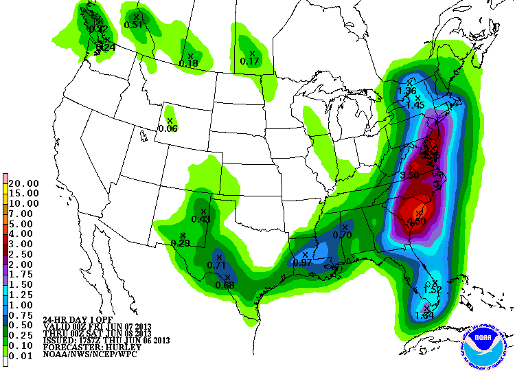
Day 2

Days 1 - 2

Total Precipitation From Tropical Storm Andrea

Wednesday, June 5, 2013

BREAKING NEWS : TROPICAL STORM ANDREA HAS FORMED AND WILL GET ADVISORIES WITHIN THE NEXT HOUR
 Return to Atlantic Graphical TWO
1. AN AIR FORCE RECONNAISSANCE AIRCRAFT WAS ABLE TO IDENTIFY A WELL-DEFINED CIRCULATION IN THE LOW PRESSURE AREA OVER THE EAST- CENTRAL GULF OF MEXICO LATE THIS AFTERNOON. BASED ON THIS FINDING...THE NATIONAL HURRICANE CENTER WILL INITIATE ADVISORIES ON TROPICAL STORM ANDREA WITHIN THE NEXT HOUR OR SO. THIS SYSTEM HAS A HIGH CHANCE...NEAR 100 PERCENT...OF BECOMING A TROPICAL CYCLONE DURING THE NEXT 48 HOURS.
New NHC Update As Of 5:00 PM EST On Invest 91L
1. A BROAD AND ELONGATED AREA OF LOW PRESSURE OVER THE CENTRAL GULF OF
MEXICO CONTINUES TO PRODUCE A LARGE AREA OF THUNDERSTORMS AND WINDS
TO NEAR GALE FORCE OVER THE SOUTHEASTERN GULF OF MEXICO.  SATELLITE
AND SURFACE DATA SUGGEST THAT THE CIRCULATION REMAINS POORLY
DEFINED...HOWEVER AN AIR FORCE RESERVE RECONNAISSANCE AIRCRAFT IS
SCHEDULED TO INVESTIGATE THE DISTURBANCE THIS AFTERNOON.  ALTHOUGH
ENVIRONMENTAL CONDITIONS ARE NOT CONDUCIVE FOR SIGNIFICANT
DEVELOPMENT...THERE IS POTENTIAL FOR THIS SYSTEM TO BECOME A
TROPICAL DEPRESSION OR STORM BEFORE IT MOVES ACROSS NORTHERN
FLORIDA LATE THURSDAY OR THURSDAY NIGHT.  THIS SYSTEM HAS A HIGH
CHANCE...60 PERCENT...OF BECOMING A TROPICAL CYCLONE DURING THE
NEXT 48 HOURS.
THIS SYSTEM HAS ALREADY PRODUCED TORRENTIAL RAINS AND FLOODING
OVER THE EASTERN YUCATAN PENINSULA AND WESTERN CUBA.  REGARDLESS
OF DEVELOPMENT...ADDITIONAL HEAVY RAINS AND GUSTY WINDS ARE
EXPECTED OVER THE FLORIDA KEYS AND THE FLORIDA PENINSULA DURING
THE COUPLE OF DAYS.  ISOLATED TORNADOES ARE ALSO POSSIBLE OVER
THE FLORIDA PENINSULA LATE TONIGHT THROUGH THURSDAY.  ADDITIONAL
INFORMATION ON THIS SYSTEM AND ITS EFFECTS CAN BE FOUND IN HIGH
SEAS FORECASTS ISSUED BY THE NATIONAL WEATHER SERVICE...AND IN
PRODUCTS ISSUED BY YOUR LOCAL NATIONAL WEATHER SERVICE OFFICE OR
NATIONAL METEOROLOGICAL SERVICE.
Tuesday, June 4, 2013
New Update From NHC On Invest 91L
1. DISORGANIZED SHOWERS AND THUNDERSTORMS ASSOCIATED WITH A BROAD AREA
OF LOW PRESSURE OVER THE CENTRAL GULF OF MEXICO ARE LOCATED WELL
EAST AND SOUTHEAST OF THE CENTER. ENVIRONMENTAL CONDITIONS COULD
BECOME A LITTLE MORE CONDUCIVE FOR DEVELOPMENT DURING THE NEXT DAY
OR TWO BEFORE THE LOW INTERACTS WITH AN UPPER-LEVEL TROUGH. THIS
SYSTEM HAS A MEDIUM CHANCE...40 PERCENT...OF BECOMING A SUBTROPICAL
OR TROPICAL CYCLONE DURING THE NEXT 48 HOURS AS IT MOVES SLOWLY
NORTHWARD TONIGHT AND WEDNESDAY AND BEGINS TO MOVE MORE QUICKLY
NORTHEASTWARD ON THURSDAY. REGARDLESS OF DEVELOPMENT...LOCALLY
HEAVY RAINS ARE LIKELY TO CONTINUE OVER THE NORTHEASTERN YUCATAN
PENINSULA...CENTRAL AND WESTERN CUBA...AS WELL AS THE FLORIDA KEYS
AND THE FLORIDA PENINSULA DURING THE NEXT FEW DAYS. ADDITIONAL
INFORMATION ON THIS SYSTEM CAN BE FOUND IN HIGH SEAS FORECASTS
ISSUED BY THE NATIONAL WEATHER SERVICE...AND IN PRODUCTS ISSUED BY
YOUR LOCAL NATIONAL WEATHER SERVICE OFFICE OR NATIONAL
METEOROLOGICAL SERVICE.
Subscribe to:
Posts (Atom)