
Tuesday, October 14, 2014
NORTHEAST WEATHER ACTION HAS RETURNED
We are back in action, we will be posting weather updates and forecasts on our facebook pages as well as here on our website!

Thursday, November 7, 2013
WEBSITE NOTICE
If you are wondering why there has been a significant lack in posts, it's because I am on a different website, PLEASE VISIT THIS LINK! - http://ssstormchasing.com/
Tuesday, October 29, 2013
Details On Possible Friday Severe T-Storm Threat
It's been quite a long time since we have had even a possibility to see strong thunderstorms. But even though it's late October, Mother Nature has different plans! So lets get started with the overall setup. A very strong low pressure system out west, teaming up with strong winds aloft and a weak cape are all combining to build a very favorable atmosphere for severe thunderstorms. The chance of strong storms will mainly be in the southern part of our region, but it's a significant chance so we have to focus on it! The time frame looks to be during the afternoon on Friday, and the storms will likely move northeast or east. And with that, here is our forecast map for Friday's Severe T-Storm Threats!


Sunday, October 27, 2013
Halloween 2013 Weather Forecast
Believe it or not, Halloween has rolled around again! For the past two years, we have had catastrophic storms that majorly impacted the Northeast US, so what it is in store for this Halloween? Believe it or not, it should be a very quiet Halloween. Although there is a chance for a few showers in Ohio, besides that it looks clear throughout the rest of the northeast. Temperatures should be in the upper 40's to upper 50's, which is unseasonably warm! Have a great Halloween 2013 everyone and stay safe! Here is our Halloween 2013 Weather Forecast map!


Saturday, October 19, 2013
This Week's First Flake Forecast
Can you believe it's already late October? So now lets look back at the last two late October's as far as weather. Last year, we had Hurricane Sandy, one of the most devastating storms in weather history, and two years ago, we had a major snowstorm with areas as far south as the mason-dixon line seeing intense snows. But what is in-store for this year? There will be some wet snowflakes in areas that would normally see snow around this time of year, but we really don't know what is going to happen from the 27th through 31st.
Generally the regions we expect to see snow this week are the mountainous areas and locations close to the lake. Obviously the parts of the northeast we expect to see the heaviest accumulations are the highest evaluations. It won't be anything big, but these snowflakes will just remind you that winter is on the way, and very soon! From there, we really don't know is going to happen, but at this point we are just going to leave this possibility of widespread snow out there, but the confidence of that is not big. Here is a map of areas that could see snow this week!

We will continue to update you on the possibility of snow and will provide the latest snowfall forecast as we get closer to the event. Further more, don't forget to stay right here because if the newly made tradition continues, around Halloween, there will be a large snowstorm for widespread areas on the northeast. So stay right here, "Like" Northeast Weather Action on facebook, subscribe to Northeast Weather Action on YouTube. Thanks for reading and have a great rest of your day everyone!
Generally the regions we expect to see snow this week are the mountainous areas and locations close to the lake. Obviously the parts of the northeast we expect to see the heaviest accumulations are the highest evaluations. It won't be anything big, but these snowflakes will just remind you that winter is on the way, and very soon! From there, we really don't know is going to happen, but at this point we are just going to leave this possibility of widespread snow out there, but the confidence of that is not big. Here is a map of areas that could see snow this week!

We will continue to update you on the possibility of snow and will provide the latest snowfall forecast as we get closer to the event. Further more, don't forget to stay right here because if the newly made tradition continues, around Halloween, there will be a large snowstorm for widespread areas on the northeast. So stay right here, "Like" Northeast Weather Action on facebook, subscribe to Northeast Weather Action on YouTube. Thanks for reading and have a great rest of your day everyone!
Monday, October 14, 2013
Winter Is Almost Here, But Lets Take Our First Step!
Can you believe it's already the middle of October, and it could snow around the area in less than a month! But lets not get ahead of our selves, we still have a quite a lot of fall left, and with that of course comes fall-like temperatures. I have said this before, but this time they are here to stay, obviously until winter. So what is to come in the next 10 days or so in weather?
The answer will relieve many of you, and that is 40's, 50's, and 60's. Yes, that cool! For the next couple days, temperatures should be around average, but from there, everything literally goes down-hill, as far as temperatures. Every day starting Friday will drop about 2 degrees lower than the previous day. So here is what we expect as far as temperatures in about a week or so, these are the HIGHS for that day!
The answer will relieve many of you, and that is 40's, 50's, and 60's. Yes, that cool! For the next couple days, temperatures should be around average, but from there, everything literally goes down-hill, as far as temperatures. Every day starting Friday will drop about 2 degrees lower than the previous day. So here is what we expect as far as temperatures in about a week or so, these are the HIGHS for that day!
 |
| 00Z EURO AT 168 HOURS FROM 10/14/13 |
Monday, October 7, 2013
Saturday, October 5, 2013
Wet Weather on the Way for the Northeast, and How Much? Find Out!
Over the past several months, the weather conditions have been on the dry side, with the abnormally dry conditions that have been spreading across the area on the drought monitor, is any improvement of the way? Well actually, there is quite a bit of rainfall that will arrive late tomorrow, though Monday, and into the first half of Tuesday. But before we get on that situation, lets go back and take a look at the current drought monitor.


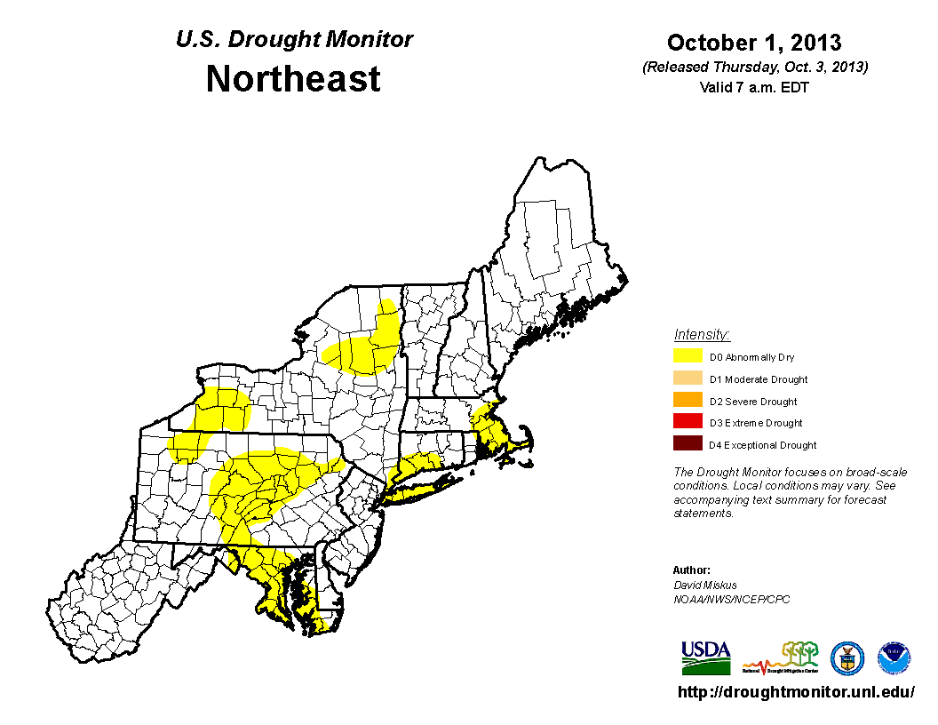
As you can see, the majority of abnormally dry conditions have been in the southern, central, and eastern parts of the area. But enough of that, lets return to the upcoming rain topic. So where is this rainfall being produced from. First, there is a cold front traveling across the Ohio Valley right, now and will produce heavy rainfall along the frontal boundary. This will also arrive at nearly the same time as the remnants of Karen. Although the track of Karen is far south of the area, the cold front will funnel up the moisture into the southern parts of the region. Here is the 72 Hour Rainfall Totals Projection.

As you can see, the heaviest rainfall will be in the western, and central parts of the northeast, with a little gap in the middle where there could be a lull in precipitation when there is rainfall on either sides of those locations, but not in that region. As you head east, a little less rainfall is expected because the rainfall from the cold front will not have as much coverage when it eventually meets the New England, Eastern New Jersey areas.
Here are the timings of this event. Some moderate to heavy precipitation should be in Ohio and Michigan by later tomorrow afternoon. After that, the precipitation will travel into Pennsylvania, as well as Western and Central New York, by Monday Morning. But the heavier rainfall will likely not arrive in New York and Pennsylvania until later on Monday, into Monday Night. Continuing on, the rainfall will likely be steady across Ohio and Michigan. So the summary of all of this is, the rain is back, and on the noticeable side! Have a great rest of your weekend, and stay dry everyone!
Tuesday, October 1, 2013
October 2013 Weather Forecast (Temperatures & Precipitation)
As apposed to the abnormally dry conditions in the month of September (last month), this month should be slightly different. So lets get started with the temperature expectation. In the beginning of the month into the middle, above average temperatures should be anticipated cause by a large ridge, that will stay in place for the long term. But as for the end of the month, we expect cooler weather conditions to arrive, and are not quite yet ruling out that late October Snowstorm that we are used to seeing, for the past couple years. So to summarize the month, overall warmer conditions will rule with cooler conditions late. So with that said, here is our October 2013 Temperature Forecast.


Now lets get back to the precipitation side of things. This October, near normal rainfall is on tap. But that could all be changed with one major rainstorm, which we could possibly have, so see that article involving that. But otherwise, there is not much to talk about, and we will see what plays out. This was your October 2013 Weather Forecast, thanks for reading and stay safe everyone!
Sunday, September 29, 2013
A Dry, Seasonal Start To The Week? Your Forecast Is Here!
Here is your weather forecast for Monday September 30th, 2013, lets get started with the expected temperatures. Overall, we are looking at mainly 60's and 70's across the commonwealth with very isolated upper 50's as highs at higher mountain ranges. Compared to normal, these are seasonal temperatures just to say, in case you were wondering. So that's a wrap for the temperatures, now lets get into the rain that could dampen some plans. Well, there is not much to talk about at all, with the exception of a dissipated cold front causing a few scattered rain showers in the Ohio region. Here is the simulated radar for late tomorrow morning. There is not much to see to say the least.


This has been your Monday September 30th, 2013 weather forecast, thanks for reading, stay safe and have a great start to your week everyone!
Tuesday, September 24, 2013
Could The Negative NAO Continue Into The Winter? Find Out!
Over the past couple weeks, a negative NAO has been dominant. These are part of a group we call teleconnections, they have an impact on our temperatures, precipitation, and overall weather pattern. They are dictated by sea surface in a certain region. The NAO is short for North Atlantic Oscillation. This is an area of of water, in of course the Northern Atlantic, that has fluctuating sea surface temperatures. When the water in the area is cold, then we are in a phase called the Negative NAO. If the waters are are warmer than normal, we would be in a Positive NAO. Here is a graphic that details the weather conditions when we are in each of these phases.


As you can see, when we are in a Negative NAO, we typically experience colder and snowier conditions across the Northeast US. When we are in a Positive NAO, we see warmer temperatures than normal. So now lets get to what this article is really about. Lately, we have been seeing a Negative NAO, which is why for the past two weeks, generally below average temperatures have been occurring in the region. We expect this pattern to continue into the winter, which would greatly impact on this winter, possibly enhancing the probability of an above average snowfall this winter, as well as cold temperatures. Here are the current NAO models for just the next two weeks, but like I said could possibly go on into the winter.

As you can clearly see, we have been having colder water in the Northern Atlantic. Although it looks like we could return to a Neutral NAO. But then right after, if will likely fall right back down into the negative phase. I am not saying the NAO will be negative indefinitely for the whole fall and winter. Of course we could have some spikes where the NAO rises positive. But a Negative NAO definitely looks like it could continue in the long range. So this is a good factor that like that graphic indicates, a cold and snowy winter. Thanks for reading and don't forget, our 2013 - 2014 Winter Outlook: 3rd Update is going to be released this Saturday. Have a great and safe rest of your day!
Friday, September 20, 2013
A Wet Weekend Of Weather Is On Tap
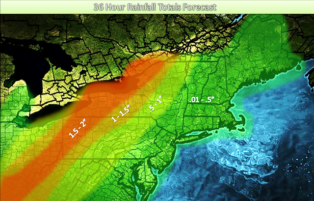
This week, it has been drier than we would expect with only a minimal probability of showers each day. So can we keep this luck into the weekend? The answer will disappoint most which is, no the rain is back in a big way. As a cold front moves through the region in the afternoon tomorrow, ahead of it will be some heavy rain.
Locations such as the majority oh Ohio, Western & Central Pennsylvania, and Western New York will get dumped on. After that the intensity of the band of rain will calm down a little as it moves into New Jersey and New England by Sunday. So with that, here is the 36 Hour Rainfall Forecast. Have a great weekend!
Locations such as the majority oh Ohio, Western & Central Pennsylvania, and Western New York will get dumped on. After that the intensity of the band of rain will calm down a little as it moves into New Jersey and New England by Sunday. So with that, here is the 36 Hour Rainfall Forecast. Have a great weekend!

Wednesday, September 18, 2013
Tuesday, September 17, 2013
Is Fall Here For Good? Find Out!
Over the past few days into today when you took a step out the door, it has felt more like October, which is of course next month. So why have the weather conditions been this cool? At first, over the weekend a cold front made it's way down from Canada, which held high temperatures across the area to a maximum of 70 degrees. But normally troughs only last for a couple days, and then are out of here. Well, yesterday a reinforcing shot of fall weather flew down from Canada and once again provided below average temperatures. Look at tonight, widespread 30's in most inland locations anywhere from the Mason - Dixon line of Pennsylvania and Maryland to Springfield, Massachusetts. In Burlington and Caribou, temperatures could drop down into the 20's, causing freezes in Northern New England and Northern New York.
So the question comes with all of this and also just the time of year, if fall here for good? Well, the answer may upset some people including me, which is no, it's not. The end of this week will feature slightly warmer temperatures, possibly up in the upper 70's, depending on where you are located. But then, by Sunday and especially into Monday of next week, cooler temperatures are back. So when will the warmth return for longer than a few days? Well most likely the end of next week. A ridge in the central plains will likely take several days to move through the midwest and into the northeast US, but it will find it's way over here some way or another. Just like I said , this is a long way out, but we are very certain that fall will fade away eventually. Here is the GFS model showing warmer temperatures on Friday September 28th. The model says Saturday, but Saturday 00Z means later in the day on Friday.

So the question comes with all of this and also just the time of year, if fall here for good? Well, the answer may upset some people including me, which is no, it's not. The end of this week will feature slightly warmer temperatures, possibly up in the upper 70's, depending on where you are located. But then, by Sunday and especially into Monday of next week, cooler temperatures are back. So when will the warmth return for longer than a few days? Well most likely the end of next week. A ridge in the central plains will likely take several days to move through the midwest and into the northeast US, but it will find it's way over here some way or another. Just like I said , this is a long way out, but we are very certain that fall will fade away eventually. Here is the GFS model showing warmer temperatures on Friday September 28th. The model says Saturday, but Saturday 00Z means later in the day on Friday.

As you can see, this model shows widespread middle to upper 70's. Continuing on, it's not just this model that indicates late summer-like temperatures will be back. So to wrap things up, just hang in there because it looks like this warm up won't last long, but we only have moderate confidence on that. remember to stay warm tonight though because in most regions of the area, if there was any precipitation it could snow tonight. But we are not expecting any of that just yet! If you have not seen our 2013 - 2014 Active Winter Storm Tracks Forecast, it's the post below this one and I encourage you to read it. Keep tuned to Northeast Weather Action for more interesting and useful weather updates, forecasts, and outlooks. Thanks for reading and have a great and safe rest of your day everyone!
Monday, September 16, 2013
Official 2013 - 2014 Active Winter Storm Tracks Forecast
Here is our official 2013 - 2014 active winter storm tracks forecast. In this discussion, we will detail the expected popular storm tracks this upcoming winter. This analysis will feature the impacted areas of the track and what the storm typically brings with it into the effected regions. Some people think we are very far out from winter, but in a month and a half, we could possibe see snow if the yearly late October storm comes, so this is the official forecast. Lets get started!
Nor'easter
A Nor'easter is the strongest impacting storm type, that can hit the US during the winter time. This storm typically forms in the Central Pacific, and moves to the northeast. After over land, the storm slams the effected regions with large amounts of precipitation. It commonly first hits the Northern Baja California Coast, and continues to move northeast for a few hundred miles, before making a turn to mainly to the east. It continues on the Mexico, US border until going back into the Western gulf of Mexico. Here, the storm strengthens by pulling in any gulf moisture it can get, before making a northeastward turn into the Northern Florida area. From here, it dumps heavy amounts of mainly rain across Florida, Georgia, and South Carolina, before making a northerly turn. After this act, it continues up the Southeast and Mid-Atlantic Coastlines, grabbing more moisture from the Atlantic and at the same time, impacting the states of South Carolina, North Carolina, and the Southern Virginia area. But during this time, the low pressure travels over a sea surface anomaly off the coast between Myrtle Beach and Ocean City, Maryland. This rapidly strengthens the storm system into a powerful winter storm. During this time, it tracks just off the Mid-Atlantic Coast, and dumps mainly rain in Eastern and Central North Carolina.
Also, depending on the pattern situation, the precipitation type could transitions from rain to ice in Southern and Central Virginia. Now, at it's maximum capability, it slams the Del-Mar-Va with a mix of rain and snow, and hits inland portions of Northern Virginia, Central and Eastern Maryland, Central and Eastern Pennsylvania, all of New Jersey (Southern part could have mixed precipitation depending on temperature), Southeast New York, and Southern New England. The snowfall totals are usually significant in the range of 6 inches plus, depending on a few factors. Sometimes, this system can phase with a weaker low from the inland areas in the Mid-Atlantic, thus strengthening the system, and normally not throwing the main storm off track. Another factor is the temperatures, which could vastly impact the snow ratios, thus changing snow totals.
The heaviest amounts of snow are normally in Southern New England. But sometimes, the heavier amounts can be further south. This is because there could be an intense trough that protects New England from seeing heavy precipitation from the system, and the storm could be shunted off the New Jersey, or Long Island Coast, with minimal effects on Southern New England. If the storm continues up the Northeast US Coastline, which it most of the time does, Central and Eastern Northern New England are also effected by heavy snow and blowing winds. Although the snow totals are still heavy in Northern New England, the area that normally sees the most snow out of Nor'easters is the Worcester Hills of Massachusetts. The lifespan of this severe winter storm normally is around 6 - 10 days, depending on speed and motion of the low pressure. There are about 2 or 3 of these type of storm systems per winter. This is the lifespan of the most famous and greatly impacting winter storm, the Nor'easter.
Total amount of expected Nor'easters for the upcoming 2013 - 2014 winter: 3 to 5; Above Average Activity
Alberta Clipper
The Alberta Clipper is a common winter storm, but definitely not the most severe out of them all. The Alberta Clipper is what it sounds like, it typically originates in Alberta, which a region in the west part of Central Canada. After forming, it moves southeast, into the Northern Plain states. Here, it brings a light to moderate snowfall on our standards, meaning around 4 - 6 inches of the good stuff. After that point, the storm track usually bends more towards the east-southeast. The next cities in line are Milwaukee, Chicago, and Indianapolis. Precipitation type at this point typically remains primarily all snow, and drops around 3 - 5 on the stated cities. Although, sometimes in Indianapolis, ice is a factor in the forecast. This is what I would call, "The Halfway Point," in the storms life.
Continuing on, the storm moves through the eastern sections of the Midwest, and enters the Ohio Valley, still holding a good 3 or 5 inches of snow. When the storm finally gets to the Northeast, it has weakened slightly, and sometimes only produces 2 - 4 inches in the Southern half of New York, Pennsylvania, Northern West Virginia, Northern Maryland, most of New Jersey, and far Southern New England. On occasions, the system will be stronger, and possibly produce upwards of 5 or 6 inches. This whole process generally takes about 5 days. Just to say, sometimes the storm system can be related with a cold front. The snow produced by this system is generally on the fluffy side, which is easier to shovel. There are normally around 3 to 5 Alberta Clippers every winter, Now you know as much as you need to know about the Alberta Clipper.
Total amount of expected Alberta Clippers for the upcoming 2013 - 2014 winter: 3 to 5; Average Activity
Colorado Low
The Colorado Low is a storm that is beginning to become a bit more well known. What it is, is a storm that's forms in the Central Pacific, and moves directly east into the San Francisco area. Of course the precipitation type is all rain, until in moves into the higher elevations of the Sierra Nevada mountain ranges. This is where moderate to heavy amounts, usually about a foot of snow falls. It continues it's long lasting journey into the Nevada - Utah region. Here, it rains in the lowlands and snows in the highlands, which are mainly located in the Northern Arizona and Southern Utah locations. The snowfall amounts there usually total around a foot, depending on elevation. After that, the system moves into Southern Colorado, impacting the Central Rockies with heavy amounts of snow, normally the precipitation type is this area is all snow, just because the Colorado area is made of highlands and full of mountains. During this time period in the storms life span, it intensifies into a strong winter storm, which it why it's called a "Colorado Low." The snow totals are normally around 8 inches to a foot in the Colorado Springs, Denver region. Obviously depending on temperatures, which is associated with elevations.
Next, the low pressure system travels into the Central Plains, and sometimes can be a wintry mix by now. This is because of the drop in elevation. For cities like Wichita and Kansas City, it can be an icy/snowy mix, depending on temperature. They normally see around 6 inches of snow and up to a quarter of an inch of ice! Then, the storm continues it's intense rage into the Midwest, where locations such as Chicago and St. Louis are impacted. Usually, Chicago sees mainly snow, while St. Louis could be having mixing issues. Snowfall totals in Chicago normally exceed 10 inches, and in St. Louis, as much as a half and inch of ice can accumulate, and then on top, another 2 to 6 inches of wet snow. Next comes the Ohio Valley, where things really get interesting. Heavy amounts of blowing snow are found in the Northern Indiana and the Northern Ohio areas. But when you move south into the Central And Southern portions of Indiana and Ohio, a common event for these people plays out. A major ice storm hits Indianapolis and Columbus with nearly an inch of ice. Meanwhile, Cincinnati is having mainly rain, with some mixed in ice. Totals here are not as significant, but still notable.
The final step of this great winter storm now plays out as it moves into Central West Virginia, Northern Virginia, and Northern Maryland. Significant amounts of heavy snow pound Northern and Central Pennsylvania, Southern New York, and into Northern New Jersey. Snowfall totals here are close to 1 foot. But as you get down into Southern Pennsylvania, to Central and Southern New Jersey, mixing issues become a small problem. In South Central Pennsylvania, typically the precipitation type is mainly snow with a little sleet or ice. Snowfall amounts here are generally around 6 to 8 inches. As you head over to Southeast Pennsylvania, and over to Central and Southern New Jersey, it becomes more of a half an half deal. Now of course all of this depends on temperatures in the area at the time, but this is what will usually happen. In cities like Philadelphia and Atlantic City, snowfall totals are limited to about 3 to 5 inches. Sleet amounts are not much and rainfall amounts are around a quarter of an inch, depending on the intensity of the storm. But this is where things upset snow-lovers in New England. At this point, generally there is nothing to steer the low, and it goes out to sea. There are around 2 to 4 of these systems per winter, but some recent winter seasons saw more. This is the life cycle of the Colorado Low.
Total amount of expected Colorado Lows for the upcoming 2013 - 2014 winter: 3 to 5; Slightly Above Average Activity
Panhandle Cutter
The Panhandle Cutter is a storm that does not have an impact on our region directly, but is a branch off of a storm track that does effect us. But lets go in detail about the Panhandle Cutter. The original storm forms in the Pineapple Express, an area around Hawaii that creates a storm about once a month during the winter. Then, the storm moves northeast, to the Northwest United States Coast. Here, the storm dumps heavy snow in the mountain areas of Oregon and Washington, and produces mainly rain in Portland, and sometimes a mix in Seattle. After this act, the storm changes movement to the southeast, and plows it's way down the center of the Rookies. During this time, it dumps as much as 3 to 4 feet of snow on the Rockies. Continuing on, the storm makes it's way down to the Texas Panhandle, where it throws as much as 8 inches of snow at cities like Amarillo. This is where sometimes the storm system can cut to the northeast, and make it's way through the South Central Plains.
After hitting Southern Oklahoma and Dallas with mainly rain, and possibly some ice, the storm makes it's way through Arkansas. Here, an icy mess can occur depending on the temperature, in areas such as Little Rock, and sometimes Memphis, Tennessee. After that, the storm can impact St. Louis with a mix of ice and snow, snow totals are normally held to only about 4 - 6 inches around the southern Illinois and East Central Missouri area. But this is where things can get fun. The storm barrels it's way through the central part of Illinois, and into Chicago. In Chicago, strong winds and snowfall totals in excess of a foot are common. This is the end of the storms life cycle. Each year, we typically see around 1 or 2 or these type of storms. The snowfall produced by this storm is generally on the wetter side south, and the direr side near Chicago. Now you know everything you need to know about the Panhandle Cutter.
Total amount of expected Panhandle Cutters for the upcoming 2013 - 2014 winter: 2 to 3; Slightly Above Average Activity
Appalachian Runner
Appalachian Runners are the last common storm to take place every winter. The take the same path as the Panhandle Cutters, until the Texas Panhandle. Here, they continue on with their journey and not travel into the Midwest US. They continue on their way through the southeast, laying mainly rain down for cities such as Jackson, Birmingham, and Atlanta. Sometimes in Atlanta and especially to the north of the city, some ice and snow can mix in, depending on temperatures at the time. After this occurs, the system moves up the eastern side of the Appalachian Mountains. This spreads heavy snow into the Appalachian Mountains of extreme Northern South Carolina, North Carolina, and Virginia. Snow totals normally amount to as much as a foot on the highest peeks of the mountains. The normal snowfall on about a 3000 foot mountain in this area is generally about 8 inches, depending on the temperature, which would control snowfall ratios.
Precipitation type is normally rain for cities like Raleigh. For Roanoke, a mix of snow and ice is often expected out of an Appalachian Runner. After this, the storm moves northeast into West Virginia, Central and Western Virginia, Central and Western Maryland, and Central and Western Pennsylvania. The average snowfall in the mountains of these areas is around a foot. In the regions where the elevations are between 400 - 1000 feet, snowfall around 4 - 8 inches is generally expected, for cities like Hagerstown and Harrisburg. For Baltimore and Washington DC, normally rain is the overall precipitation type with some mixed ice and sleet for a short period. Then, the storm moves north into Northern Pennsylvania and the highlands of Central and Eastern New York. In these regions, all snow is the usual precipitation type because of high elevation and great snowfall ratios. Snowfall totals are typically between 12 and 18 inches in this storm. The snowfall is usually a drier snow, except in the lower elevations of South Central Pennsylvania, where a normal, slightly wet snow would be expected. These storms usually occur around 1 time a winter. These are all the details about the unique Appalachian Runner.
Total amount of expected Appalachian Runners for the upcoming 2013 - 2014 winter: 1 to 2; Slightly Above Average Activity
So you have just read all of the details about what we should expect the most active storm tracks to be for the upcoming 2013 - 2014 Winter. I hope you managed to read at least a few sections of this forecast if not the entire article. Here is our official 2013 - 2014 Winter storm Tracks graphic. The lines are colored as the titles of each storm are. Thanks for reading and have a great, safe rest of your day!

Nor'easter
A Nor'easter is the strongest impacting storm type, that can hit the US during the winter time. This storm typically forms in the Central Pacific, and moves to the northeast. After over land, the storm slams the effected regions with large amounts of precipitation. It commonly first hits the Northern Baja California Coast, and continues to move northeast for a few hundred miles, before making a turn to mainly to the east. It continues on the Mexico, US border until going back into the Western gulf of Mexico. Here, the storm strengthens by pulling in any gulf moisture it can get, before making a northeastward turn into the Northern Florida area. From here, it dumps heavy amounts of mainly rain across Florida, Georgia, and South Carolina, before making a northerly turn. After this act, it continues up the Southeast and Mid-Atlantic Coastlines, grabbing more moisture from the Atlantic and at the same time, impacting the states of South Carolina, North Carolina, and the Southern Virginia area. But during this time, the low pressure travels over a sea surface anomaly off the coast between Myrtle Beach and Ocean City, Maryland. This rapidly strengthens the storm system into a powerful winter storm. During this time, it tracks just off the Mid-Atlantic Coast, and dumps mainly rain in Eastern and Central North Carolina.
Also, depending on the pattern situation, the precipitation type could transitions from rain to ice in Southern and Central Virginia. Now, at it's maximum capability, it slams the Del-Mar-Va with a mix of rain and snow, and hits inland portions of Northern Virginia, Central and Eastern Maryland, Central and Eastern Pennsylvania, all of New Jersey (Southern part could have mixed precipitation depending on temperature), Southeast New York, and Southern New England. The snowfall totals are usually significant in the range of 6 inches plus, depending on a few factors. Sometimes, this system can phase with a weaker low from the inland areas in the Mid-Atlantic, thus strengthening the system, and normally not throwing the main storm off track. Another factor is the temperatures, which could vastly impact the snow ratios, thus changing snow totals.
The heaviest amounts of snow are normally in Southern New England. But sometimes, the heavier amounts can be further south. This is because there could be an intense trough that protects New England from seeing heavy precipitation from the system, and the storm could be shunted off the New Jersey, or Long Island Coast, with minimal effects on Southern New England. If the storm continues up the Northeast US Coastline, which it most of the time does, Central and Eastern Northern New England are also effected by heavy snow and blowing winds. Although the snow totals are still heavy in Northern New England, the area that normally sees the most snow out of Nor'easters is the Worcester Hills of Massachusetts. The lifespan of this severe winter storm normally is around 6 - 10 days, depending on speed and motion of the low pressure. There are about 2 or 3 of these type of storm systems per winter. This is the lifespan of the most famous and greatly impacting winter storm, the Nor'easter.
Total amount of expected Nor'easters for the upcoming 2013 - 2014 winter: 3 to 5; Above Average Activity
Alberta Clipper
The Alberta Clipper is a common winter storm, but definitely not the most severe out of them all. The Alberta Clipper is what it sounds like, it typically originates in Alberta, which a region in the west part of Central Canada. After forming, it moves southeast, into the Northern Plain states. Here, it brings a light to moderate snowfall on our standards, meaning around 4 - 6 inches of the good stuff. After that point, the storm track usually bends more towards the east-southeast. The next cities in line are Milwaukee, Chicago, and Indianapolis. Precipitation type at this point typically remains primarily all snow, and drops around 3 - 5 on the stated cities. Although, sometimes in Indianapolis, ice is a factor in the forecast. This is what I would call, "The Halfway Point," in the storms life.
Continuing on, the storm moves through the eastern sections of the Midwest, and enters the Ohio Valley, still holding a good 3 or 5 inches of snow. When the storm finally gets to the Northeast, it has weakened slightly, and sometimes only produces 2 - 4 inches in the Southern half of New York, Pennsylvania, Northern West Virginia, Northern Maryland, most of New Jersey, and far Southern New England. On occasions, the system will be stronger, and possibly produce upwards of 5 or 6 inches. This whole process generally takes about 5 days. Just to say, sometimes the storm system can be related with a cold front. The snow produced by this system is generally on the fluffy side, which is easier to shovel. There are normally around 3 to 5 Alberta Clippers every winter, Now you know as much as you need to know about the Alberta Clipper.
Total amount of expected Alberta Clippers for the upcoming 2013 - 2014 winter: 3 to 5; Average Activity
Colorado Low
The Colorado Low is a storm that is beginning to become a bit more well known. What it is, is a storm that's forms in the Central Pacific, and moves directly east into the San Francisco area. Of course the precipitation type is all rain, until in moves into the higher elevations of the Sierra Nevada mountain ranges. This is where moderate to heavy amounts, usually about a foot of snow falls. It continues it's long lasting journey into the Nevada - Utah region. Here, it rains in the lowlands and snows in the highlands, which are mainly located in the Northern Arizona and Southern Utah locations. The snowfall amounts there usually total around a foot, depending on elevation. After that, the system moves into Southern Colorado, impacting the Central Rockies with heavy amounts of snow, normally the precipitation type is this area is all snow, just because the Colorado area is made of highlands and full of mountains. During this time period in the storms life span, it intensifies into a strong winter storm, which it why it's called a "Colorado Low." The snow totals are normally around 8 inches to a foot in the Colorado Springs, Denver region. Obviously depending on temperatures, which is associated with elevations.
Next, the low pressure system travels into the Central Plains, and sometimes can be a wintry mix by now. This is because of the drop in elevation. For cities like Wichita and Kansas City, it can be an icy/snowy mix, depending on temperature. They normally see around 6 inches of snow and up to a quarter of an inch of ice! Then, the storm continues it's intense rage into the Midwest, where locations such as Chicago and St. Louis are impacted. Usually, Chicago sees mainly snow, while St. Louis could be having mixing issues. Snowfall totals in Chicago normally exceed 10 inches, and in St. Louis, as much as a half and inch of ice can accumulate, and then on top, another 2 to 6 inches of wet snow. Next comes the Ohio Valley, where things really get interesting. Heavy amounts of blowing snow are found in the Northern Indiana and the Northern Ohio areas. But when you move south into the Central And Southern portions of Indiana and Ohio, a common event for these people plays out. A major ice storm hits Indianapolis and Columbus with nearly an inch of ice. Meanwhile, Cincinnati is having mainly rain, with some mixed in ice. Totals here are not as significant, but still notable.
The final step of this great winter storm now plays out as it moves into Central West Virginia, Northern Virginia, and Northern Maryland. Significant amounts of heavy snow pound Northern and Central Pennsylvania, Southern New York, and into Northern New Jersey. Snowfall totals here are close to 1 foot. But as you get down into Southern Pennsylvania, to Central and Southern New Jersey, mixing issues become a small problem. In South Central Pennsylvania, typically the precipitation type is mainly snow with a little sleet or ice. Snowfall amounts here are generally around 6 to 8 inches. As you head over to Southeast Pennsylvania, and over to Central and Southern New Jersey, it becomes more of a half an half deal. Now of course all of this depends on temperatures in the area at the time, but this is what will usually happen. In cities like Philadelphia and Atlantic City, snowfall totals are limited to about 3 to 5 inches. Sleet amounts are not much and rainfall amounts are around a quarter of an inch, depending on the intensity of the storm. But this is where things upset snow-lovers in New England. At this point, generally there is nothing to steer the low, and it goes out to sea. There are around 2 to 4 of these systems per winter, but some recent winter seasons saw more. This is the life cycle of the Colorado Low.
Total amount of expected Colorado Lows for the upcoming 2013 - 2014 winter: 3 to 5; Slightly Above Average Activity
Panhandle Cutter
The Panhandle Cutter is a storm that does not have an impact on our region directly, but is a branch off of a storm track that does effect us. But lets go in detail about the Panhandle Cutter. The original storm forms in the Pineapple Express, an area around Hawaii that creates a storm about once a month during the winter. Then, the storm moves northeast, to the Northwest United States Coast. Here, the storm dumps heavy snow in the mountain areas of Oregon and Washington, and produces mainly rain in Portland, and sometimes a mix in Seattle. After this act, the storm changes movement to the southeast, and plows it's way down the center of the Rookies. During this time, it dumps as much as 3 to 4 feet of snow on the Rockies. Continuing on, the storm makes it's way down to the Texas Panhandle, where it throws as much as 8 inches of snow at cities like Amarillo. This is where sometimes the storm system can cut to the northeast, and make it's way through the South Central Plains.
After hitting Southern Oklahoma and Dallas with mainly rain, and possibly some ice, the storm makes it's way through Arkansas. Here, an icy mess can occur depending on the temperature, in areas such as Little Rock, and sometimes Memphis, Tennessee. After that, the storm can impact St. Louis with a mix of ice and snow, snow totals are normally held to only about 4 - 6 inches around the southern Illinois and East Central Missouri area. But this is where things can get fun. The storm barrels it's way through the central part of Illinois, and into Chicago. In Chicago, strong winds and snowfall totals in excess of a foot are common. This is the end of the storms life cycle. Each year, we typically see around 1 or 2 or these type of storms. The snowfall produced by this storm is generally on the wetter side south, and the direr side near Chicago. Now you know everything you need to know about the Panhandle Cutter.
Total amount of expected Panhandle Cutters for the upcoming 2013 - 2014 winter: 2 to 3; Slightly Above Average Activity
Appalachian Runner
Appalachian Runners are the last common storm to take place every winter. The take the same path as the Panhandle Cutters, until the Texas Panhandle. Here, they continue on with their journey and not travel into the Midwest US. They continue on their way through the southeast, laying mainly rain down for cities such as Jackson, Birmingham, and Atlanta. Sometimes in Atlanta and especially to the north of the city, some ice and snow can mix in, depending on temperatures at the time. After this occurs, the system moves up the eastern side of the Appalachian Mountains. This spreads heavy snow into the Appalachian Mountains of extreme Northern South Carolina, North Carolina, and Virginia. Snow totals normally amount to as much as a foot on the highest peeks of the mountains. The normal snowfall on about a 3000 foot mountain in this area is generally about 8 inches, depending on the temperature, which would control snowfall ratios.
Precipitation type is normally rain for cities like Raleigh. For Roanoke, a mix of snow and ice is often expected out of an Appalachian Runner. After this, the storm moves northeast into West Virginia, Central and Western Virginia, Central and Western Maryland, and Central and Western Pennsylvania. The average snowfall in the mountains of these areas is around a foot. In the regions where the elevations are between 400 - 1000 feet, snowfall around 4 - 8 inches is generally expected, for cities like Hagerstown and Harrisburg. For Baltimore and Washington DC, normally rain is the overall precipitation type with some mixed ice and sleet for a short period. Then, the storm moves north into Northern Pennsylvania and the highlands of Central and Eastern New York. In these regions, all snow is the usual precipitation type because of high elevation and great snowfall ratios. Snowfall totals are typically between 12 and 18 inches in this storm. The snowfall is usually a drier snow, except in the lower elevations of South Central Pennsylvania, where a normal, slightly wet snow would be expected. These storms usually occur around 1 time a winter. These are all the details about the unique Appalachian Runner.
Total amount of expected Appalachian Runners for the upcoming 2013 - 2014 winter: 1 to 2; Slightly Above Average Activity
So you have just read all of the details about what we should expect the most active storm tracks to be for the upcoming 2013 - 2014 Winter. I hope you managed to read at least a few sections of this forecast if not the entire article. Here is our official 2013 - 2014 Winter storm Tracks graphic. The lines are colored as the titles of each storm are. Thanks for reading and have a great, safe rest of your day!

Sunday, September 15, 2013
Saturday, September 14, 2013
7 Day Weather Forecast (Temperatures & Precipitation)
Over the next week of weather, we will have a fall-like pattern. So lets jump right into the temperatures. In the next 2 days, an exiting though will allow temperatures to reach the upper 60's to middle 70's, obviously depending on location. By Tuesday, a reinforcing cold shot will fly down from Canada, packing more cooler temperatures, meaning highs on Tuesday will most likely only reach 70 in most locations across the northeast. By the later part of next week, a ridge will build in from the central plains, bringing warmer temperature along with it of course.
Now I would have to say, it will only bring our temperatures back to average at best for a few days, before more cold air flows down in about 10 days. But the temperatures will be most below average in the inland portions or our region, where the through will be centered for a couple days. By the coastal regions of our region, slightly below normal temperatures to just average temperatures will be common in the next 7 days. Here is the 7 day temperature forecast comparison to normal.

Lets jump to the precipitation side of things now. Overall, the Northeast US will see below average precipitation in the middle of it, with slightly below average precipitation on the eastern and western parts of the area. The only spots likely to see slightly above average precipitation will be the western half of Ohio. Of course, any precipitation that fall in our region will be rainfall, except maybe on Mt.Washington, but I would have to say not many people live there. The pattern will be pretty persistent for the next week, which is why there is not much to talk about in terms of rain. So here is the 7 day precipitation forecast: comparison to normal.

Now I would have to say, it will only bring our temperatures back to average at best for a few days, before more cold air flows down in about 10 days. But the temperatures will be most below average in the inland portions or our region, where the through will be centered for a couple days. By the coastal regions of our region, slightly below normal temperatures to just average temperatures will be common in the next 7 days. Here is the 7 day temperature forecast comparison to normal.

Lets jump to the precipitation side of things now. Overall, the Northeast US will see below average precipitation in the middle of it, with slightly below average precipitation on the eastern and western parts of the area. The only spots likely to see slightly above average precipitation will be the western half of Ohio. Of course, any precipitation that fall in our region will be rainfall, except maybe on Mt.Washington, but I would have to say not many people live there. The pattern will be pretty persistent for the next week, which is why there is not much to talk about in terms of rain. So here is the 7 day precipitation forecast: comparison to normal.

Wednesday, September 11, 2013
Any Cooler Temperatures Down The Pipeline? Find Out!
Today and yesterday were days that nobody likes. Can you guess why besides political issues, THE HEAT! Widespread 80's and 90's have been the most common temperature. Which as you know, is summer-like, and we are all tired of summer, so that's enough of this nonsense. Tomorrow will be the last day of this heat, before a major cool down is here! By Friday, highs will be held to the 60's and lower 70's everywhere around the region. At night, temperatures will get down to the 30's and 40's also around the area. Ooh yea, that's just the start of the good news. On Saturday, temperatures will be in the upper 50's north will lower the lower 60's in the southern mountains. In the Big cities such as Boston, New York, and Philly, temperatures won't even hit the 70 degree mark.
This pattern will continue into the majority of next week, with once again temperatures stuck in the upper 60's to middle 70's as highs across the Northeast US. This all is a reasult of a cold front digging down from central and eastern Canada, that will hold temperatures down. After that, a reinforcing shot of cold air will race it's way into the northeast on Tuesday. With all of this occuring, below normal temperatures should prevail until the ridge in the Central US moves east, and brings our temperatures back up to the middle and upper 70's to 80's. That is in the longer range, but will likely play out. I am not saying it will get even close to how hot it is now during that period of time, but what I'm trying to say is enjoy this cool down while it lasts. Here is a GFS model hour where I think best forecasts the high temperatures for Sunday through Thursday of next week. Thanks for reading and have a great, safe rest of your day!

This pattern will continue into the majority of next week, with once again temperatures stuck in the upper 60's to middle 70's as highs across the Northeast US. This all is a reasult of a cold front digging down from central and eastern Canada, that will hold temperatures down. After that, a reinforcing shot of cold air will race it's way into the northeast on Tuesday. With all of this occuring, below normal temperatures should prevail until the ridge in the Central US moves east, and brings our temperatures back up to the middle and upper 70's to 80's. That is in the longer range, but will likely play out. I am not saying it will get even close to how hot it is now during that period of time, but what I'm trying to say is enjoy this cool down while it lasts. Here is a GFS model hour where I think best forecasts the high temperatures for Sunday through Thursday of next week. Thanks for reading and have a great, safe rest of your day!

Subscribe to:
Posts (Atom)