Can you believe it's already late October? So now lets look back at the last two late October's as far as weather. Last year, we had Hurricane Sandy, one of the most devastating storms in weather history, and two years ago, we had a major snowstorm with areas as far south as the mason-dixon line seeing intense snows. But what is in-store for this year? There will be some wet snowflakes in areas that would normally see snow around this time of year, but we really don't know what is going to happen from the 27th through 31st.
Generally the regions we expect to see snow this week are the mountainous areas and locations close to the lake. Obviously the parts of the northeast we expect to see the heaviest accumulations are the highest evaluations. It won't be anything big, but these snowflakes will just remind you that winter is on the way, and very soon! From there, we really don't know is going to happen, but at this point we are just going to leave this possibility of widespread snow out there, but the confidence of that is not big. Here is a map of areas that could see snow this week!
We will continue to update you on the possibility of snow and will provide the latest snowfall forecast as we get closer to the event. Further more, don't forget to stay right here because if the newly made tradition continues, around Halloween, there will be a large snowstorm for widespread areas on the northeast. So stay right here, "Like" Northeast Weather Action on facebook, subscribe to Northeast Weather Action on YouTube. Thanks for reading and have a great rest of your day everyone!
Saturday, October 19, 2013
Monday, October 14, 2013
Winter Is Almost Here, But Lets Take Our First Step!
Can you believe it's already the middle of October, and it could snow around the area in less than a month! But lets not get ahead of our selves, we still have a quite a lot of fall left, and with that of course comes fall-like temperatures. I have said this before, but this time they are here to stay, obviously until winter. So what is to come in the next 10 days or so in weather?
The answer will relieve many of you, and that is 40's, 50's, and 60's. Yes, that cool! For the next couple days, temperatures should be around average, but from there, everything literally goes down-hill, as far as temperatures. Every day starting Friday will drop about 2 degrees lower than the previous day. So here is what we expect as far as temperatures in about a week or so, these are the HIGHS for that day!
![]() |
| 00Z EURO AT 168 HOURS FROM 10/14/13 |
Monday, October 7, 2013
Saturday, October 5, 2013
Wet Weather on the Way for the Northeast, and How Much? Find Out!
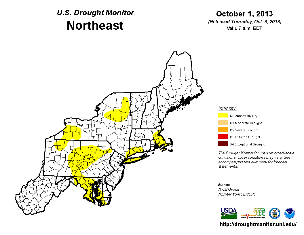
Over the past several months, the weather conditions have been on the dry side, with the abnormally dry conditions that have been spreading across the area on the drought monitor, is any improvement of the way? Well actually, there is quite a bit of rainfall that will arrive late tomorrow, though Monday, and into the first half of Tuesday. But before we get on that situation, lets go back and take a look at the current drought monitor.
As you can see, the majority of abnormally dry conditions have been in the southern, central, and eastern parts of the area. But enough of that, lets return to the upcoming rain topic. So where is this rainfall being produced from. First, there is a cold front traveling across the Ohio Valley right, now and will produce heavy rainfall along the frontal boundary. This will also arrive at nearly the same time as the remnants of Karen. Although the track of Karen is far south of the area, the cold front will funnel up the moisture into the southern parts of the region. Here is the 72 Hour Rainfall Totals Projection.
As you can see, the heaviest rainfall will be in the western, and central parts of the northeast, with a little gap in the middle where there could be a lull in precipitation when there is rainfall on either sides of those locations, but not in that region. As you head east, a little less rainfall is expected because the rainfall from the cold front will not have as much coverage when it eventually meets the New England, Eastern New Jersey areas.
Here are the timings of this event. Some moderate to heavy precipitation should be in Ohio and Michigan by later tomorrow afternoon. After that, the precipitation will travel into Pennsylvania, as well as Western and Central New York, by Monday Morning. But the heavier rainfall will likely not arrive in New York and Pennsylvania until later on Monday, into Monday Night. Continuing on, the rainfall will likely be steady across Ohio and Michigan. So the summary of all of this is, the rain is back, and on the noticeable side! Have a great rest of your weekend, and stay dry everyone!
Subscribe to:
Posts (Atom)