Wednesday, July 3, 2013

10 Day Weather Outlooks (Temperatures and Precipitation)

          Over the next 10 days, we here in the northeast will experience generally the same old pattern we have already been seeing. Generally above average temperatures throughout the northeast excluding Maine. After that, slightly above average precipitation, or rain will fall in the region with above average precipitation from Central and Western Pennsylvania, and to the south of those areas.

          So lets go a little more into detail instead of saying just plain rain. It looks like scattered thunderstorms will continue to be upon us as well as up and down the East Coast. There could be a few strong storms on hotter days like Thursday and through the weekend, into next week. But overall we shouldn't expect much of any severe thunderstorms in the next 10 days.

          Now here are the exact expected temperatures in the next week and a half, rather than just saying above average. We expect to be around the 90 degree mark starting Thursday and likely lasting through the next several days from Washington D.C. to Philadelphia to possibly as far north as New York and Boston. But for the Appalachians, all of Ohio, and Upstate New York as well as the Poconos of Northeastern Pennsylvania, middle to upper 80's is what they should expect in those regions.

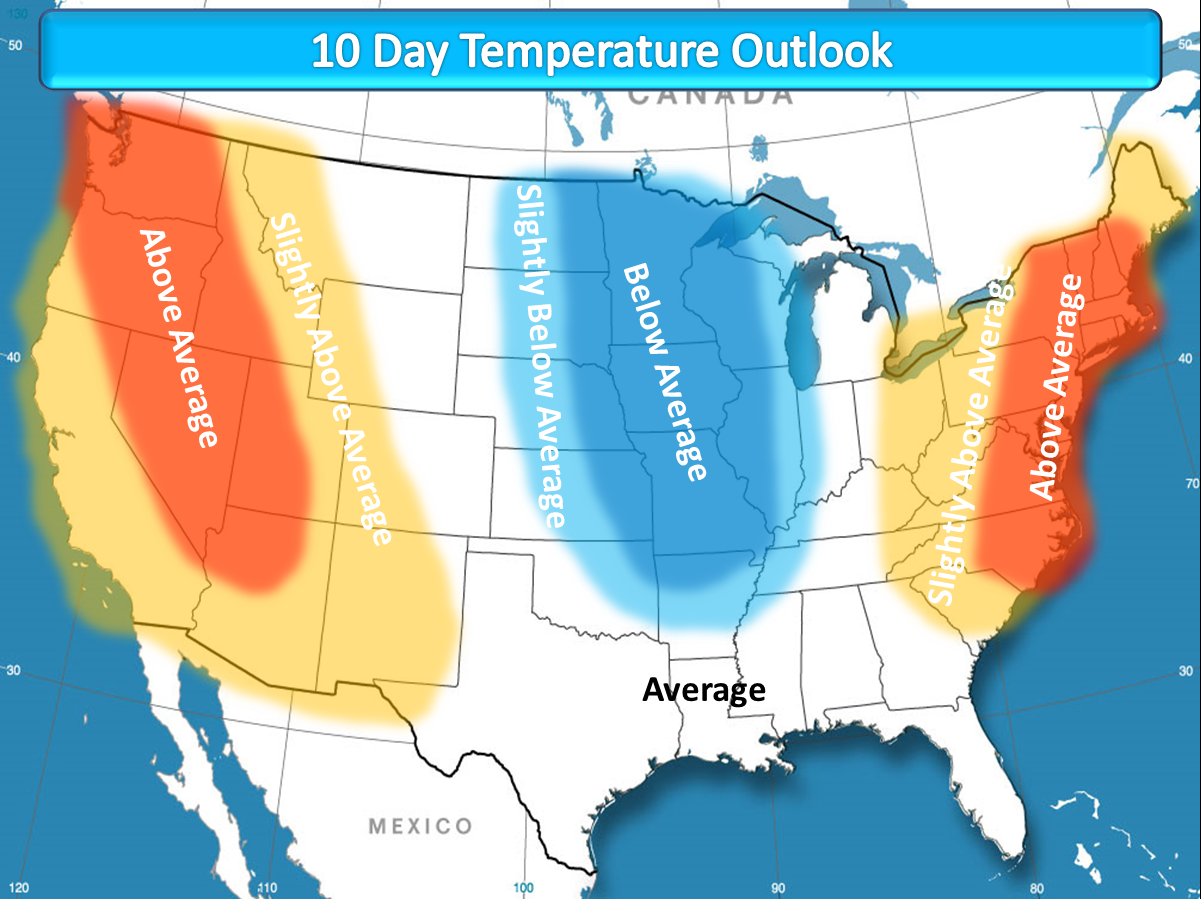
          Lastly areas in Northern New England will see upper 70's to lower 80's as highs. So this is the general description of weather on the way in the next 10 days here in the northeast United States. If you would like to look at what the rest of the country will likely be seeing in terms of temperatures and precipitation in the next week and a half, there are maps below. Thanks for reading and as always stay tuned to Northeast Weather Action for the latest weather forecasts and updates! Have a great day and stay safe everyone!


Tuesday, July 2, 2013

Latest 4th Of July Fireworks Forecasts Are Out!

          As we inch closer and closer to the 4th Of July, we now have a very good idea of what the weather will likely be this year. So will you show be ruined, it depends where you are. If you plan to attend a fireworks show anywhere from Charleston, West Virginia to Pittsburgh, PA, to Buffalo, New York, you could run into some rain showers. Anywhere else outside of those areas should just expect hit or miss t-storms for the day on Thursday with things likely clearing out just in time for sunset.

          Now lets switch to the temperatures for Thursday. Temperatures will likely be in the 70's and 80's. But that is during the day on Thursday, at sunset temperatures will likely be around 5 degrees colder than that. So when you look at this map, these are the daytime high temperatures, so to determine the forecast temperatures at around 9:00, just take about 5 - 8 degrees off and you know. So here are the detailed maps for temperatures and weather conditions for Thursday. As always stay tuned to Northeast Weather Action for the latest forecasts and updates. Have a great and safe rest of your day!


The Heat Almost Here! But Just How Hot?


          I take you though a few models and express my thoughts on the coming heat wave. Don't forget to LIKE Northeast Weather Action.

Monday, July 1, 2013

Will The Rain Ever Stop? Find Out!

          Will the rain ever stop, a question being asked by many people across the East Coast as storm after storm continues to dump rain on the region. But do we have an answer to that question that many people will enjoy, unfortunately not. What looks most likely, the next 10 days scattered thunderstorms will continue to sit on the region. Now this does not necessarily mean rainy times all day every day. When scattered thunderstorms are in the forecast, on the day of scattered storms, clouds and possibly sun with a few storms will be around, not all day rain. Ok now that is the next 10 days, so what is after that?

          This is the part of this article I know you will not love to hear at all. In the next 8 or 10 through 14 days, above average precipitation will yet again be centered over the region, likely bringing more significant rainfall events across the region. After that, which is about two weeks from now, it's looking like things will finally get back to normal, which is very hard to believe. So this is the summary of precipitation coming to our area in the next 14 or even 21 days. Have a great day and I will leave you with the 8 - 14 day precipitation outlook.


Warm Or Cool Temperatures On The Way? Find Out!


              I take you through a few weather models we use here at Northeast Weather Action to predict the upcoming weather. See just how hot things will get and don't forget to LIKE Northeast Weather Action on facebook!

Our YouTube Videos